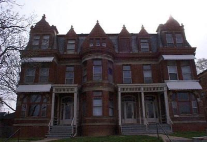
In the late 1980s, only a few steps east of the present Interstate 480 boundary, stood an immense and mysterious apartment building. An early Omaha relic by then, 563 South Twenty-eighth Street was still fully functional and known for her peculiar beauty. I became acquainted with the building when a sophisticated ballerina girl, with long blonde hair lived there with her mother, also a remarkable beauty reminiscent of Joni Mitchell from 1970. Although I never knew them well, theirs was a Bohemia of the mind, backlit by this unique building, entirely inhabited by beautiful, creative people. My roommate was employed at Daydream card shop in the Old Market alongside the Joni Mitchell mother and would occasionally provide her transportation to her striking home at 563 South Twenty-eighth Street. I observed the large apartment building from the rear seat.
It seems in those days a tall, ornate, double globe, parlor lamp, rose-hued and hand-painted, welcomed at a front window. There were multiple front doors, an assortment of windows adorned with curtains and a honey-toned glow, human silhouettes, cats, plants, a ribbed, Asian paper lantern. Peter Lorre smoking in the shadows of the porch. The high rooms and roofline were inconceivable. I believed it was possibly a mansion when constructed—the kind of practical mansion once owned by a man named Ambrose, whose descendants later converted his home to apartment suites. What might the grand staircase be like? How many fireplaces would I find? To sleep in a servant’s little cubby room tucked near the kitchen. Eventually there were other friends who rented in the stately building. I didn’t know it, but at that time 563 South Twenty-eighth was already a centenarian and one of the last holdouts of a vanished time.
At a Glance: The historic apartment building at 563 South Twenty-eighth Street was boarded up in the 2000s. Her history is obscure, and the proposed building dates from past research are inconsistent as are names. This investigation aimed at clearing up her construction date, the identity of the original owner with historical backdrop, the current situation, and the reasons behind her boarded status.

My roommates and I lived right across I-480 to the southwest at 1040 South Twenty-ninth Street in kindred lodgings (shown above). We knew there was a very strong possibility that these two character-buildings were half-sisters or surely shirttail cousins in their day, only separated by a few neighborhood streets and other behemoth homes. Unfortunately, by our time, the inescapable freeway had long ago split the two relations. It was unsettling to consider that the freeway cutting between the apartment buildings, the rows of residences, all gone. I would lay in bed in my front bedroom, listening to the incessant roar of traffic through the trees, the rumbling trucks of I-80, attempting to imagine it as the trackbed of a lower railway or a tranquil, meandering river. Even though I have yet to offer up my deep dig on 1040 South Twenty-ninth Street, please check out: Park Avenue Recollection in the mean time.
I have finally completed the investigation on 1040 South 29th Street. Please read it when you have a chance. Here’s the link: WE HAVE ALWAYS LIVED IN THE CASTLE: A HISTORY OF OMAHA’S GEORGIA ROW HOUSE.


Aerial images from 2025 and 1955 displayed side by side. The yellow rectangle encircles the 563 South Twenty-eighth apartment building. The red rectangle delineates 1040 South 29th Street. The blue outlines the structures lost to Interstate 480 (I-480), also referred to as the Gerald Ford Freeway, situated between Twenty-eighth and Twenty-ninth streets. Freeway construction began in the early 1960s. Aerials found at the DOGIS site.
The whole area was sparsely rented by artists, pensioners, the working class, long-time families, students, the occasional hustler, true characters. I don’t know why it was, but in the 1980s, it was customary for these glorious monuments to have unoccupied suites, abandoned floors even, yet they continued to serve the needs of existing tenants. No one threatened to dismantle them (of course I wouldn’t have known much about that if they did) and the proprietors appeared unconcerned with maintaining full occupancy in every apartment. Rough and beautiful, with just enough architectural dignity, these neighborhoods remained too run down, eccentric and poorly lit, perhaps associated with the working class, to entice this contemporary wave of heritage-fueled gentrification developers* currently observed in Omaha. (*The phenomenon of Omaha developers demolishing historic housing to replace with new, high-density housing to “sell back” a curated interpretation of that very history to wealthier residents.) It was the perfect urban eco-system. As previously mentioned in our past investigations, the absence of inhabitants in these charming pockets of Old Omaha and its abandoned quality only contributed to the surrealistic dreamworld movie set of my mind. The multiethnic neighborhood maintained a detached attitude towards our youthful inclinations and likely perceived us as ephemeral, having witnessed other tenants’ fleeting whims over the decades. To my teen eyes, the regulars appeared as strange as we did. Many of us were restless, romantic souls who had vacated much more habitable homes for the wilds of Old Omaha, longing to attain a past-life aesthetic, soak in like-minded nostalgic taste, mystery, and historic richness. It was a portal to the past. The affordable rents made our modest retro life possible, allowing sufficient funds for records, alcohol, thrift clothes and paints for impromptu bedroom wall murals and similar endeavors. This impulse would bring new perils and at times privations that propelled a strange narrative, becoming one with the very architecture’s storyline.
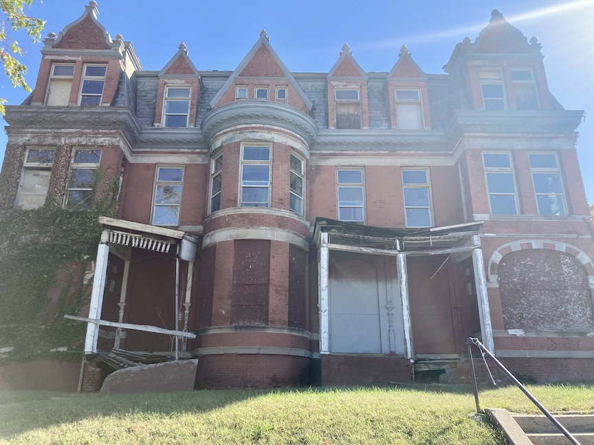
To look at the current 563 South Twenty-eighth is a sad, sad sight. The glorious and strange beauty was boarded up in the 2000s and possibly some can no longer remember a time when it was not. And none knew why it was so closed. We have all watched it moulder away. Less than a handful of writings concerning the apartment building have emerged since the 1970s and within them, the clues are scant and conflicting. I hope I can contribute its historical context through my investigation, and I aim to clarify the present condition of the deteriorating building, as well as share my interpretation of the owner’s intentions concerning this property based on clues uncovered.

Many only experience her from the interstate view. She still glows at the Golden Hour, right before sunset, just east of the I-80.


Let us begin looking into the curious gaps between things.
I would like to open the 563 South Twenty-eighth Street case file by sharing brief observations of the area, as well as important clues I collected from prior research conducted by others.
Preliminary Report
The 563 South Twenty-eighth Street structure is situated in the Park East area, between St. Mary’s Avenue and Howard Street. The building has had three addresses for most of its existence: 563, 565, and 567 South Twenty-eighth Street; nevertheless, for the sake of simplicity in our discussion today, we will refer to it as 563. The Park East district is roughly bordered by Dodge, Twentieth, Leavenworth, and Twenty-eighth Streets and characterized as a commercial and residential zone just west of Omaha’s downtown. While some may deem it a run-down area, some gathered here, love and appreciate it as I do and I frequently highlight it for our investigations.

Aerial image borrowed from Google Map. I highlighted the Park East district in yellow. For the record, no one I knew called it Park East and we wouldn’t have known it even had a name. That being said, the powers that be have renamed it again: The Quarters.
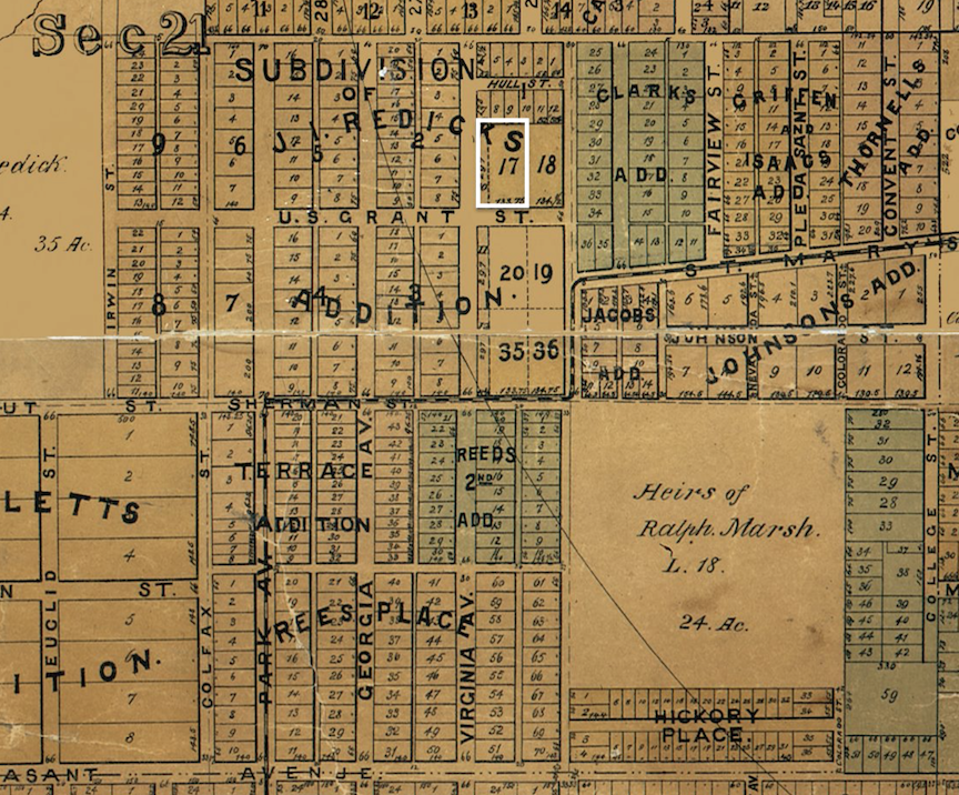
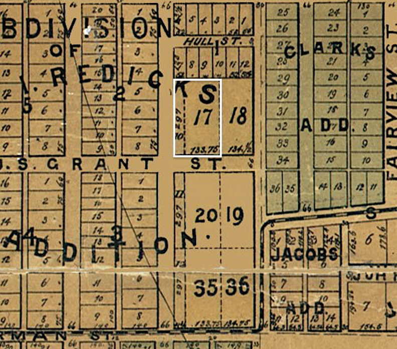
Although this was named the much later named the Park East district, the property at 563 South Twenty-eighth Street is located within the J. I. Redick addition, Lot 017, Block 010, specifically. Some may perceive my festering regarding these additions as trivial tasks; however, city addition designations are significant as they provide a strong historical marker —a concrete legal record and a spatially defined representation of urban expansion, economic, and social conditions that contributed to Omaha’s footprint. The historical clues merit investigation—street layouts, parcel dimensions, architectural cohesion, or variance for that matter. Mr. John Irwin Redick moved to Omaha in 1856 and attained significant prominence as an attorney, judge, civic leader and politician. I have documented him in our past investigations but for our purposes today we are most interested in his real estate development. (When you have time, please peruse: The Case of Park Avenue and the Mysterious Hospital for more details on Judge John I. Redick.) Because this won’t be one of my long-drawn-out investigations, we will leave these details in the dark for tonight. The basics are that Redick had amassed hundreds upon thousands of acres of Omaha land, simply called the John I. Redick land. By the 1860s he was buying, selling, and occasionally building on his property. So much land was gathered that Omaha City would buy from Redick occasionally. The first plat initiation under the formal John I. Redick (J. I. Redick addition) plat name occurred in the 1870s or earlier; there would be a similarly named subdivisions, splitting tracts of land into multiple, smaller lots and replat modifications which seemed to reconfigure existing recorded lot boundaries. It should be noted that there are further Redick developments around town; however, the specifically named “J. I. Redick” lots are situated within the boundaries of South Twenty-seventh, Leavenworth, Dewey Avenue, and South Thirty-first Street. This obviously indicates a unified neighborhood, prior to the silly-named Park East, before the Interstate was constructed.

J. I. Redick additions, subs and replats outlined in lime green. This is not to say that every lot in this square is a Redick lot. Aerial image borrowed from DOGIS.
Addendum of March 30, 2026*** This just in–the most beautiful map of 1883.
Lovely Map of the City of Omaha, 1883. Published by George P. Bemis’ real estate agency, compiled under direction of Andrew Rosewater, City Engineer. Drawn by Jacob Hauck, Borrowed from Omaha Public Library. I outlined in white the property site. For orientation, north is the top of the map.
The previous map, enhanced. Again 563 South 28th Street, Lot 17 is outlined in white. In some portions of Omaha, South 28th Street was called Virginia Avenue. Map of the City of Omaha, 1883. Published by George P. Bemis’ real estate agency, compiled under direction of Andrew Rosewater, City Engineer. Drawn by Jacob Hauck, Borrowed from Omaha Public Library.

1890 Sanborn Map shared by Trina Westman and Shelley McCafferty. Please note that our 563 South Twenty-eighth was/is situated on Block 10 shown above. Jackson Street and Howard served as the boundaries of the block. St. Mary’s Avenue is displayed on a jog to the south. The 10 block is presently capped by St. Mary’s Avenue.

1955 aerial borrowed from DOGIS. 563 South Twenty-eighth Street is outlined in magenta. Jackson Street, now gone in this part of town, is highlighted in yellow. It opens onto South Twenty-seventh Street. Leavenworth Street is toward the lower portion of the photograph. The earlier version of St. Mary’s Avenue cuts at an angle and is out of view to the right (east). City planning altered these roadways in response to the I-680 design from the early 1960s.
Recognizing that Omaha in 1889 was predominantly populated in the downtown vicinity, stretching both to the north and south, the westward expansion to Twenty-eighth Street was a significant departure from the urban core. The extension of streetcars to areas deemed “suburban” residential lots facilitated this development. This specific area of the town was never the most affluent or characterized by opulence (as would be seen to west on Georgia Avenue/South Twenty-ninth Street and later in the Hanscom Park neighborhood) but this part of Omaha was very nice, populated by professional people, business owners, etc, renting large, lovely duplexes and renting or owning spacious single-family homes. Also, as we shall see, adventurous, progressive people looking to invest in new westward moving Omaha parcels. A survey of Sanborn Maps of the 1890s displayed a mix of apartment buildings, duplexes and single family homes in the neighborhood of our focus.
563 South Twenty-eighth is a west-facing structure and sits directly on the Park East boundary, adjacent the interstate. The brief Twenty-eighth Street block from Howard Street on the north to St. Mary’s Avenue, (formerly capped on the south by Jackson Street, which disappeared in the early 1960’s reconfiguration of the interstate), was once chock-full of homes on both sides of the street. The western section was forfeited to the interstate plan, resulting in a chain-link fence now bordering that side of the block. South Twenty-eighth Street has been designated as a one-way thoroughfare that unexpectedly converges with the interstate exit beyond Howard Street. The situation is precarious and sloppy. Now I normally love a quirky street layout but this merger can be dangerous with vehicles that are in a godawful hurry to get somewhere. The peculiarities persist with Howard Street, which runs east-west as a very slim, two-way thoroughfare for half a block, rendering it a charming and quiet street. Dewey Avenue, located one block to the north, is a one-way street that exclusively permits westbound traffic only for extra uncertainty. I will add that this segment of Dewey Avenue was once called Half Howard Street, which makes more sense in terms of functionality. I acquired this from my preferred quirky street history book: The Streets of Omaha: Their Origins and Changes by H. Ben Brick. 1997.

563 South Twenty-eighth Street property outlined in magenta. 563 South Twenty-eighth Street is situated on the eastern side of south Twenty-eighth, facing the Interstate. A hop and skip over and there is my former apartment in a four-plex on South Twenty-sixth Avenue. I can recount many lessons learned on these strange and wonderful blocks.

563 South Twenty-eighth Street is situated on a slightly elevated position on the eastern side of Twenty-eighth. She very clearly is the most ornate and oldest building in this area. A brief exploration of these blocks will make plain. The original dwellings on South Twenty-eighth were dismantled long ago, leaving only infill or subsequently constructed buildings. The left side of the image reveals the rear of the row houses on Howard Street. The right side of the photo show the edge of the 569 South Twenty-eighth apartment building.

An operational albeit somewhat unsatisfactory, Midcentury Modern apartment building is situated to the south at 569 South Twenty-eighth. Originally the address was 571 South Twenty-eighth Street and built in 1953. (Popping back in to say that the addresses are both used to this day?) These structures are found throughout Omaha and were constructed during an era when proprietors aimed to maximize the number of apartments within a limited space. I deem it a cultural transgression to have a front entry that does not orient towards the street. It is rude. To complicate the situation, a basement door was later installed that does face the street along with an auxiliary building featuring another side door. I see London. I see France.

A vacant field adjoins it. Now fenced in, it is looking forlorn. There are other empty lots behind 563/571 South Twenty-eighth Street as well on the Twenty-seventh Street side. We will discuss the absences later.


The southern-most structure on this short block of South Twenty-eighth Street is a Domino’s Pizza oriented south on St. Mary’s Avenue.

A mysterious building located to the east bears the address 540 South Twenty-seventh Street. (More on that later.) Between 540 South Twenty-seventh (seen above) and the Domino’s Pizza is the Omaha Housing Authority Jackson Tower apartments located at 600 South Twenty-seventh.

As this Google image depicts, it was not too long ago that the MCM apartment building had a large tree to its east, giving privacy to that odd entrance. The empty field west of 540 South Twenty-seventh was still being mowed. The Jackson Tower is seen in the distance.

Twenty-eighth Street, now a one-way. Chainlink fence of the Interstate seen on the left side of photo. The 563 South Twenty-eighth Street building seen on the right hand side.

Twenty-eighth Street headed north. Right lane must turn onto quiet half block, Howard. Left lane must stop at a sign and then merge with those cars exiting the Interstate. Beyond, Dewey Avenue is one way and other roads are blocked because of the new street car city design.


Delicious brick details that I thought you would appreciate.

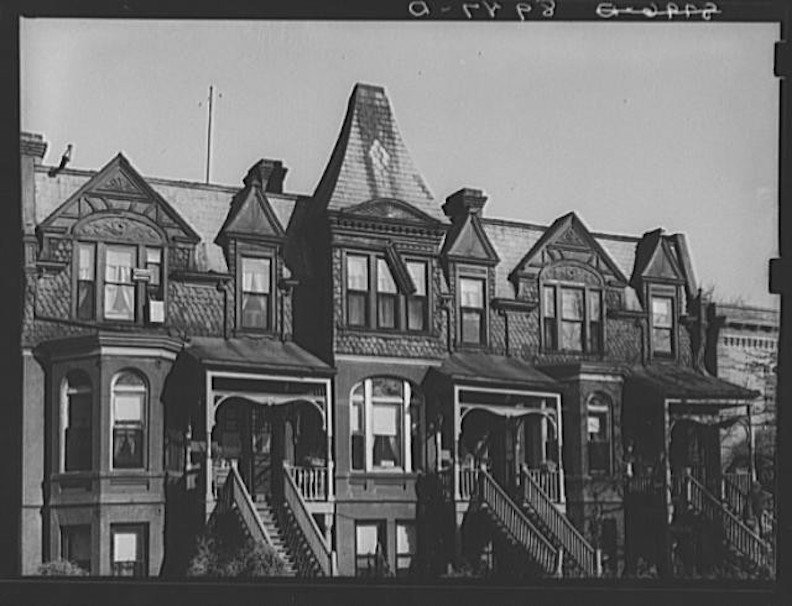
Around the corner to the east on Howard Street and within close proximity to 563 South Twenty-eighth are a series of row houses that I really like. These brick flats have done some heavy lifting in style since the early 1900s. They comprise 2727, 2725, 2721, 2719 and 2717 Howard Street.

Here the flats are depicted in a more aesthetically pleasing era, characterized by well-maintained porch columns, an attractive porch roof, and elaborate woodwork. Originally given the address 515 South Twenty-eighth Street, these flats were built as six-unit rowhouse in 1910. Photo borrowed from the Downtown Survey Photos (1981).
Other parcels on short Howard Street and South Twenty-eighth have had their residences razed, leaving the adjoined properties vacant.

The northeast corner of South Twenty-eighth and Howard Street. This empty lot between Howard and Dewey once contained six domestic structures. The building in the distance, on one-way Dewey Avenue, is boarded up; it was constructed at the O’Brien-Davis-Coad Auto Company. It ain’t a pretty solution but the building was enclosed as it is the rear of Dino’s Storage located at 2725 Harney.

To the east on Howard Street, we view a lovely home built in 1901, enshrouded in trees and shrubs, empty lots to both east and west.

Here she is in 1981 when she had close neighbors on both sides. Omaha Survey photo.
The Interstate 480 thoroughfare has rendered the 563 building and remaining residential structures isolated within a discordant neighborhood due to city street design. We have witnessed what happens when city planning isolates a neighborhood by enforced one-way streets, especially in proximity to an interstate; there are lasting detrimental structural, social, and economic consequences, like this isolated pocket. There appeared to be no plan for accessibility, let alone safety, making the establishment of community or a future unfeasible. Neglectful owners, insufficient tenants, or sheer expense hindered maintenance as homes gave way or were razed over time.
Let us now move to the historical evidence obtained from prior research conducted by others.
Case Review
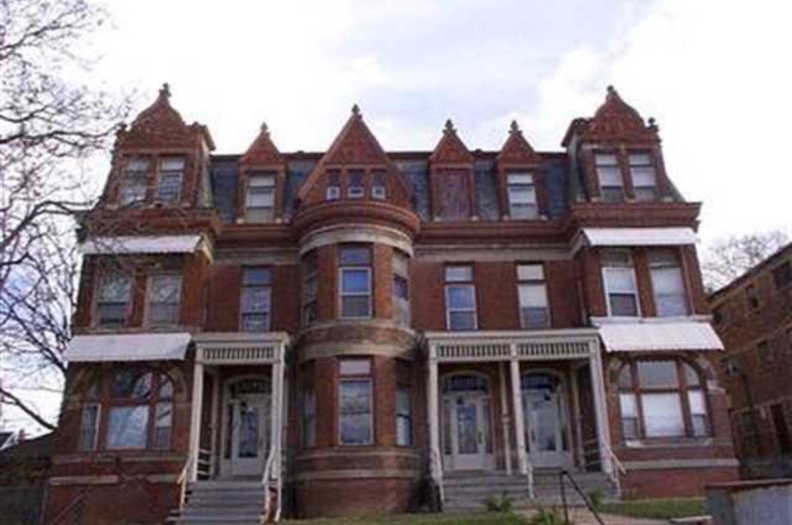
In 1977, 563 South Twenty-eighth Street was included in the remarkable Omaha City Architecture published by Landmarks, Inc. and the Junior League of Omaha, Inc. The photograph they thankfully included is the oldest of the handful of historical depictions of this magnificent structure. (Our oldest image of 563 South Twenty-eighth captured her at 90-some years old. On that note, if you have photographs of this property from an earlier time period that you would be willing to share for this research, please make contact.) Their summary:
“Duplex on Interstate 480. 563-567 South 28th Street. This three-story structure erected about 1880 is designed in the Chateauesque style. Noteworthy architectural details include masonry construction, basket-handle window arches, flat roofs, a two-story round turret, and elaborate finial-topped gables. Openings are crossed by masonry mullions and transoms. Sides and back of the structure have been covered with stucco, but the front is unaltered.
Originally built as a duplex, this building has been converted to nine apartments containing hardwood floors, paneled walls, and high ceilings. Stairways have sculptured wooden banisters. Many of the original light fixtures are still in use, and bathrooms contain the original sinks. Present owners are in the process of refurbishing this unusual building: hopefully, its rich façade will continue to benefit the city scene.”

Photograph scanned from one of my favorites: Omaha City Architecture published by Landmarks, Inc. and the Junior League of Omaha, Inc. 1977.
Later, in 1980, the same Landmarks group would log our 563 South Twenty-eighth Street building in their documentation of the remaining architectural greats of Omaha. An Inventory of Historic Omaha Buildings prepared by Landmarks Inc., under a grant from the City of Omaha and in cooperation with the Landmarks Heritage Preservation Commission. 1980. Along with other great photographs, this entry contained essential information. I have included it for your examination:
“563 S 28th St.
Date: 04-19-1889
Cost: $15,000
Original Owner: Kaufman Mrs. M.
Original Builder: SHAW
Architect(s): Cleves Bros
Outblds & Adds: 10-17-1945
Builder: Morton J.
Cost: $350
2. Date: 05-04-1961
Builder: Omaha Parking Service
Cost: $3446″


All photographs from An Inventory of Historic Omaha Buildings. Landmark Inc Survey Photos (1980). Love the (rather compressed) image they caught of the rear of the building. I do adore back entrances, fire escapes and teetering, tall, weathered porches—as Janie Rice Brother said, they tell The Other Side of the story. My friends Brian Pfeffer and Syd Reinarz identified this tough car beyond the trash cans as a 1971-1973 Buick Riviera. Do you have one for sale, by the way? We are looking.
Meanwhile in contemporary times real estate sites have 563 South Twenty-eighth Street listed at 9 units, 3 stories, built in 1896, perhaps because the Douglas County Assessor site reported 563 was built in 1896. The Nebraska architects’ site listed the structure as built in 1889.
Who? What? When? and Why?, specifically. We had a number of things to iron out.
Background Checks: Mrs. M. Kaufman
The Landmarks’ book listing of 563 South Twenty-eighth’s original owner was not lost on me: Mrs. M. Kaufman. Such a wonderfully ambiguous clue and one that hinted that her husband had possibly passed before her ownership began. I suspicioned this due to the rarity of married women owning rental properties in Omaha in the 1800s. To stave off complaints of the long, twisted process of drawing Mrs. M. Kaufman out of the shadows, I will reveal that my first meaningful clue was Mr. Henry Kaufman’s bequest of all his property to wife Mary in 1888.
Husband Henry Kaufman (sometimes written Kaufmann) was born in Germany in 1843 and immigrated to the United States in 1866. He “worked at his trade” of harness-making in Chicago until arriving in Omaha where he was employed by the Union Pacific Railroad. He later moved here in 1869 and entered “the wood business.” The story goes that Captain Geiseke was running a saloon in the basement of the Omaha Savings Bank. The Omaha journalists gathered there and it was “the center” of resort for “editors, reports and compositors of the time.” Kaufman became manager of the bar, later bought it and moved the business a number of times.

Grand announcement of the new Henry Kaufman bar, an “elegant Beer Hall,” situated between Thirteenth and Fourteenth streets on. Douglas. Omaha Daily Bee. March, 1881.

Henry Kaufman’s Douglas Street saloon was later tracked to 1314 Douglas Street. This great photograph shows the Sanford Bar at 1314 Douglas Street, years later in 1947. Sanford Bar is shown adjacent to the State Hotel stairwell. The front window has a scrumptious hand painted advertisement for Storz Beer, and the front door is ajar. The State Hotel and Sanford bar were razed, and the U. S. West building replaced it in the late 1970s. Photographer: Bostwick. Durham Museum. 1947.
Henry Kaufman married 18 year old Mary in 1872. Mrs. Mary Kaufman was also born in Germany. Obtained from a survey of U.S. Federal Census data years later, it would appear that Mary Kaufman was born in Germany circa 1854-55. She emigrated to the United States in 1871. Henry and Mary Kaufman had six daughters– Mary, Josephine, Theresa, Caroline, Catherine, Margaret and one son, Henry. The 1893 probate court reading of Peter Karbach’s will disclosed that Mrs. Mary Kaufman and her three sisters, including one still residing in Germany and another identified, interestingly, as Sister Ludowike of the Religious Order of the Precious Blood, were all beneficiaries of their father’s estate. Mary Kaufman was Mary Karbach Kaufman.
At the time of his death in 1888, Henry Kaufman was one of the best known and esteemed saloonkeepers in Omaha and “also the owner of considerable Omaha real estate.” Simultaneously Mary Karbach Kaufman’s father, Peter Karbach, was found purchasing numerous parcels in the J. I. Redick addition years prior to his death, land eventually inherited by Mrs. Kaufman and her sisters. *Near the end of my investigation I was to learn that Peter Karbach was founder of the Karbach block, at Fifteenth and Douglas Streets. This occurred at a time in early Omaha when an individual would establish a city block, develop and build the structures which also typically bore the founder’s name.

In May of 1888, Mrs. Mary Kaufman became executor of husband Henry Kaufman’s estate. Omaha Daily Bee. 1888. May.

In July of 1888, Mrs. Mary Kaufman makes moves to sell her husband’s bar. Omaha Daily Bee. 1888. July.

Jackson Tower, faces the South Twenty-seventh Street and St. Mary’s Avenue corner skew to the site boundaries.

The western wing of the Jackson Tower building was added later. It is perpendicular to the original diagonal building. The Domino’s Pizza is viewed in the foreground.
When Mr. Kaufman died in February of 1888 one article stated he passed “at his residence, No. 714 North Sixteenth Street.” But that was not the family’s home address and I am not altogether sure if he died on Sixteenth. The Kaufman family resided at 536 South Twenty-seventh Street, occasionally recorded as 537 South Twenty-seventh. The old home from the 1880s no longer exists; it was the kind of residence that was chopped up into multiple apartments. I suspect it was razed during the construction of the Jackson Tower at 536 South Twenty-seventh Street. The address of Jackson Tower was subsequently altered to 2700 St. Mary’s Avenue and later still to 600 South Twenty-seventh Street. The Omaha Housing Authority erected this substantial public housing complex as “low-rent apartments for the elderly” in 1970; one of five structures of its type in Omaha, erected in the 1968-1971 time period. (It is of particular nerd relevance that Jackson Street was the original crossover here, rather than St. Mary’s Avenue, giving full color clarity to the Jackson Tower name.) It seems that Mr. Kaufman possessed several parcels on South Twenty-seventh Street, with some lots extending to our area of interest, South Twenty-eighth. Additionally there were more parcels inherited through Mr. Karbach.
Building 563 South Twenty-eighth Street
In the spring of 1889 Mrs. Mary Kaufmann was issued a building permit.

“Three story brick block of flats on Jackson near Twenty eighth–$15,000.” Omaha Daily Bee. 1889. April. The early address seemed ambiguous–something we have come across over the years. Most likely due to not having formal addresses assigned to parcels on this block. Below you will see the Sanborn Map showing there is no nearby housing until Jackson street.

An odd report from June of 1889 stated: “Mary Kaufman, brick block, stores and flats, Twenty-eight and Jackson.” Was there an early plan to include a store/s in the large apartment building? If so, this never came to fruition. It very well might have been an error on the newspaper’s part. Omaha Daily Bee. 1889, June.
I was pleased to discover this proof. I cross-referenced with the 1889 Omaha City Directory and, as expected, there was no such location logged…yet. 536 South Twenty-eighth was the southernmost house between Howard and Jackson Streets. Of interest some prominent families of Omaha, including the Rogers, the Dr. Hoffmans, Metz, and Pease households, were discovered residing on this street. Likewise the 1890 Omaha City Directory omitted the address and tenants; nonetheless, the Omaha World-Herald published an advertisement in November 1890 seeking an “experienced cook wanted for a small family” at that location. The 1891 Omaha City Directory still lacked a listing. We have discovered in our past investigations it was common for “way out west” addresses to not be recorded in the city directory or city mapping–perhaps not formally recognized as part of Omaha or just not part of the specified catchment area of survey.
In 1890, there was definitive evidence of 563 South Twenty-eighth Street’s existence in the form of a hand-drawn Sanborn Map footprint.

1890 Sanborn Map shared by Trina Westman and Shelley McCafferty. Red arrow points to the Mrs. Mary Kaufman newest addition to the block, our 563 South Twenty-eighth property. For orientation of the map, note the atlas arrow pointing north.
To fully assess the drawings, Mrs. Kaufman had constructed a large, late Victorian residential structure including three distinct apartments, sometimes called houses (three “Ds” signifying dwellings) on three floors (the number 3 shown in each apartment). This implies that each glorious apartment encompassed three generous floors and potentially, basement space. Strangely, the building possessed just two addresses at the time of the Sanborn Map survey, as found below in the detail magnification. This building was purported to be a duplex in past research, which I contend is erroneous information. I would wager that in its initial year, the wonderful Mrs. Kaufman building featured three distinct suites, likely occupied by only two families. Mrs. Mary Kaufman did not reside here; she constructed it as a revenue-generating asset. She resided in close proximity and was able to supervise its rental.
Also of interest, the Kaufman building was situated in the middle of two large parcels of land, presumably to create a gracious space for inhabitants.

For your inspection. 1890 Sanborn Map detail (of the above image) shared by Trina Westman and Shelley McCafferty. Note the 517 and 519 South Twenty-eighth Street addresses. These addresses were reassigned soon after.
To clarify and regroup: Mrs. Kaufman submitted a building permit in April of 1889. The structure was featured in a city map from 1890. An apartment building of this size could certainly have been finished by the conclusion of 1889, provided there were no delays with finances or access to materials. Currently, we lack conclusive evidence regarding its completion in 1889 or a specific time in 1890. However, it was undoubtedly constructed prior to 1896, a widely circulated misconception. Evidence indicates that this structure has always been a tri-plex townhouse, rather than a duplex.
Canvas

This image is somewhat pixelated, but I appreciate it for encapsulating a moment of repair, when a prior owner revealed the original spindles and craftsmanship of the porch overhangs. Three entry doors and the exquisite windows are unveiled, validating the 1890 Sanborn Map drawing.

Pssst….lookey here. This roofline is a portal to the old world. The photo displays a central two-story round turret or tower complete with bay windows. Ornate, storybook gables are crowned with both ball and pineapple finials above terracotta. Pressed terracotta on 1890s buildings were a favored, resilient, and lightweight substitute for carved stone, frequently showcasing elaborate artistic features. I believe I see flowers in her terracotta. These fire-resistant, hand-pressed or mold-formed clay components—often unglazed or in earthy hues throughout this era—were utilized as decorative highlights, cornices, or sheathing to embellish masonry structures. The gray slate tiles outline the red terracotta perfectly.

White arrow points to the blueish-gray cornice serving as a belt course crown of 563 South Twenty-eighth Street. Prominent, stately, while decorative. A nice hard, substantial edge. I longed to see the behind the scenes of the cornice from the windows above.
One of my favorite features of 563, other than the overall composition and feel, is the cornice above rows of belt course. I needed to seek out Virginia Savage McAlester for more information. In 1890s apartment building, the horizontal edging that delineates the floors on the outer facade is sometimes referred to as a belt course, string course, or sill course. These characteristics were prevalent in late 19th-century Victorian architecture to visually separate stories, indicate transitions between various materials, or emphasize the building’s horizontal lines. Although they stem from structural components, by the 1890s, these belt courses mostly had a decorative purpose, intended to enhance architectural interest, generate shadows, and emphasize the building’s proportions. They also concealed the junction where floors intersected with the wall and disrupted the verticality of a multi-story, 3–4 story apartment structure, sometimes called a flat. These bands are seen extending across 563 in pale stone (limestone?) The highly detailed feature above the second floor of our 563, although separating floors is blueish-gray cornice moulding. “The crown” does not end there, above it the third floor continues to awe.
Brace yourself. Limited interior photographs from the last sale are not pretty.


These two images just in from friend, Mister Rogers. These are from an early 2000s sale. Intriguing to see the awnings but even better, the original doors!
Thank you, Mister Rogers!

Second floor room with door shoved into a missing window opening.

Spindles of the original entry were hidden behind a wood front.

East “rear” elevation. Stucco walls with back stairwell and wood decking.

North elevation is covered in foliage. This image was captured from Howard Street, through row house alleyway.

Southern elevation of 563 South Tweny-eighth Street. Favored for its resilience, and low expense as an exterior covering, stucco or cement type plaster was often used on external side walls that did not face the street, originating in the 18th and 19th centuries. Flat roof is viewed from this angle.

An examination of Virginia Savage McAlester’s bible, A Field Guide to American Houses, further explained the surge of opulence during this era.Victorian styles distinctly illustrate the transformations brought about by burgeoning industrialization, which enabled the mass production and distribution of intricate house components at comparatively low costs via the expanding railway system. The buildings from the 1880s to 1890s exemplify these transformations by their extravagant use of complex designs and ornate details, which were formerly confined to costly landmark residences for the affluent. This clarified my misconception of believing it was a mansion during my youth.
The mansard roof shapes, the dormers and window surrounds, the belt course all say Second Empire but the turret, the revealed spindle work and terracotta gable detailing read Queen Anne. The round-topped arches occurring over windows, masonry walls with rough faces, asymmetrical facade, two or more colors and textures of stone are combined to created decorative patterns was most certainly Richardsonian Romanesque. Richardsonian Romanesque is a Romanesque Revival achitecture. The more I read, I found Henry Hobson Richardson incorporated Second Empire and Queen Anne into his eclectic version of Romanesque. Mr. Richardson stressed unusual, sculpted shapes. I wager 563 South Twenty-eighth Street is a Richardsonian Romanesque building. The focus on solid masonry construction (limestone, granite, and sandstone), use of squared stonework (called Ashlar), often mixed with brick, variance in colors with rough and smooth textures, interestingly, for townhouses, mansard roofs and front gabled roofs were normally used. Broad, rounded arches were a prominent characteristic of the style, utilized around entrances and windows. In the case of 563 South Twenty-eighth Street, the two prominent front windows have been historically designated as basket handle arches. The design required the arch to be a complete semi-circle, instead of a pointed or low-spring arch found in other styles. Richardsonian Romanesque housing was much more expensive to build than were the other Late Victorian styles. “For this reason they are mostly architect designed landmarks and were never common.”
A notable aspect for me is the pleasure with which the architects of this building style distinguished the different floors of a structure. Visual appeal and narrative development were of paramount importance. The mind delights to take in one of these buildings and it is difficult to ignore the storytelling elements–at least that is what happens to me. Significantly distinct from the box apartments we are subjected to in contemporary society.
For reference I found further examples, the cohort of 563 South Twenty-eighth.
Photographer John Vachon’s 1938 snap of a wonderful, weathered Omaha apartment building.

Detroit, Michigan.

Springfield, Massachusetts.

Ottawa, Canada.
With this brief history lesson in Richardson Romanesque and insights into America’s capacity to design and build these complex structures illuminate why they may have been regarded as excessive or antiquated throughout time. Not I and surely not you agree with this. But some…I have included an illustration with spicy commentary from almost thirty years past and a painting that shows the reality of what happened.

This lovely medley of illustrations by Harry Fenn was first published in Harper’s Weekly, January 26, 1889. However in 1926, the magazine reprinted the drawings accompanied by a snippy retrofitted perspective: “These sketches of 1889 show admirable the type of city domestic architecture which characterized the late 1880s and the early 1890s, strongly influenced by the Romanesque of Richardson, as well as the traditional Queen Anne, and assimilating neither completely. It was an architecture exuberant, picturesque, but incoherent, lacking in unity, with much ill-considered detail.”

Edward Hopper’s 1927 painting, The City, displays a fanciful Late Victorian era mansion (Second Empire), possibly cut up into apartments, squeezed in by the monotony of low-rise, walkup rows and skyscrapers, cropped out of the artist’s window view.
The considerable cost of the Richardson Romanesque style explains why Omaha possessed few instances beyond the downtown business sector; I would also surmise that its bold, dramatic aesthetic was perceived as excessive for residential areas of Omaha. Aesthetically, a nice Queen Anne, Stick-Eastlake, or Folk Victorian design is far more easier on the eye. At our heart, we are straightforward and practical folk in this region.
Background Checks: The Architects
The Landmarks’ logging identified the Cleves Brothers as the historic architects of 563 South Twenty-eighth Street, a fact reiterated in historical accounts. Shaw was identified as a builder, while another publication recognized Withnell & Shaw as builders. I found no conclusive evidence that the Cleves designed this building of our fixation. Nonetheless, I did not prove that another architectural firm was responsible for its design. I shall reveal my conclusions regarding the Brothers Cleves.
The Cleves Brothers were known for “their taste and skillful designing.” Brothers and partners Charles and August Cleves operated an architect firm in Omaha from 1882 to 1896. Charles would proceed independently, a topic we shall address. Older brother, Charles L. Cleves was born in Germany in 1846 and immigrated to the United States in 1880. Younger August Cleves was born in Germany in 1858. A brief survey of their work presented examples of the Holy Family Church located at 915 North Eighteenth, Saint Wenceslaus Catholic Church situated at 1430 South Fourteenth, and the Kosters-Galinsky-French Café Building at 1013-17 Howard Street. There were many more buildings and many not listed on the official state log.

Omaha Daily Bee. 1882, March.
Cleves Brothers were mentioned in the Omaha Evening Bee, Nov 22, 1882, as architects of the West Street school addition. The Holy Family Church design came next in March of 1883. But by that May, they were charged with assault.

Omaha Daily Bee. 1883, May.

The Omaha Evening Bee. 1883, May.
In this period, the Cleves Brothers operated their architecture office in the Creighton Block downtown. A disagreement arose regarding the expenses associated with the plans for the new school at Leavenworth and Seventeenth Streets. Specht and Livesey were both practical builders and members of the school board. One of the Cleves brothers allegedly threw Specht from their offices into the hallway, where Specht struck his head against the wall. Assault and battery charges were lodged, and the brothers were to be arrested by morning. These are concerns we don’t often read of architects. We shall revisit this issue shortly. I have discovered intriguing facts regarding the structures designed during the period of 563 South Twenty-eighth.

Omaha Daily World-Herald. 1889, February.
In April 1887 the Cleves Brothers completed the Georgia Avenue school building on what is now been renamed Twenty-ninth Street. Of interest, in the summer of 1889 the Cleves Brothers designed the Pacific Express headquarters building, described as “five stories, the first two being of stone, while pressed brick and terra cotta will be used above.” Likewise in the winter of 1889, the Cleveses designed rowhouses at Twenty-sixth and Harney utilizing “brown brick, the second and mansard stories covered with grey and dark slate. Towers, dormer windows, balconies and porches” were combined. It all sounded quite similar to 563 South Twenty-eighth.
August Cleves appeared to be acquiring parcels of land in Omaha at elevated rates beginning in 1886. He seemed to frequent the courtroom regularly as time went by facing a handful of lawsuits from numerous individuals. At this point in the investigation, I was not necessarily assuming he was the brother who hurled Mr. Specht across the office.

Omaha Daily Bee. 1895, February. By 1895 August Cleves was labeled legally “insane” and was appointed a guardian. The Nebraska History Place Makers of Nebraska site reported, “He resided with his brother Charles’ family through 1900, according to the U. S. Census of that year, but the city directory of 1900 noted his residence as ‘County Hospital.’ The U.S. Census rolls of 1910 and 1920 indicate he was an inmate at the Hastings State Asylum.”
Despite the brothers being recorded as partners until 1896, it seems more probable that their professional relationship disintegrated in 1895, if not earlier. Their mentions persisted in the newspaper records until 1893, after which there is a sharp decline, with the sole reference being an ongoing court action involving Mr. Ed Maurer. Charles Cleves would continue an independent practice after August’s unfortunate detainment in a psychiatric hospital. In 1899, Charles Cleves designed the Iler Grand Hotel in the Karbach Block (serendipitous!) in downtown Omaha, which was regarded as the most luxurious hotel in town for its time. In 1908, he divested his architectural practice in Omaha to H. A. Raapke and moved to Europe, where he and his family resided in Geneva, Switzerland, and subsequently in Merano, Italy.
Evidence Collection
The history of the structure at 563 South Twenty-eighth Street was obscured, and the available evidence was fragmented. An 1890 World-Herald article listed city ordinances levying a special tax and assessment on certain lots and real estate in Omaha. This, together with other indications, revealed that Mrs. Kaufman’s new apartment complex property was registered under her deceased husband, Henry Kaufman’s name (evidently parcels acquired during his lifetime, which she inherited). Perhaps more intriguingly, the lot was once larger. The imposing Richardson Romanesque tri-plex occupied lots 17 and 18 in J. I. Redick’s addition. I could see that this would have been an impressive sight. The property border line progressively diminished over time.

Omaha Daily Bee. 1897, November.
In the initial years of Mrs. Kaufman’s rental, each of the three suites was referred to as a “ten-room house,” suggesting well-appointed, spacious accommodations across three levels. By 1897, each unit was rented for $40 per month by Byron Reed Co. (I would learn Byron Reed managed the rental property for Mrs. Kaufman.) To give context, this $40 rate would have been very expensive for the average person in 1890s Omaha and most likely represented luxury or high-end housing. Initially, Mrs. Kaufman’s triplex was not referred to as the Ormond or the Ormand. At a minimum, not advertised as such. This building name has been reiterated in historical documentation but I did not find its use until much later. Initially, 517 and 519 South Twenty-eighth, along with the third unit, each provided ten rooms and were leased as houses. By 1901 the Sanborn Map indicates that the addresses 563, 565 and 567 South Twenty-eighth Street had been given their permanent postal designations, however this 1897 advertisement also suggests the addresses had been written in stone.

1901 Sanborn Map lent by Trina Westman and Shelley McCafferty. 563 South Twenty-eighth Street outlined in red. For your orientation–atlas arrow points to the north. We are facing 563 South Twenty-eighth on the west side. If you use your magnifying glass, the three addresses (563, 565 and 567) have been entered into record. Note that the 563 building has no close neighbors yet. The mostly empty lot to the south is owned by Mrs. Kaufman and on it, an outbuilding is seen. Do I see an “A” written, possibly a carriage house turned garage? Automobiles were available in this time period but certainly rare, expensive novelties primarily for the wealthy. This clue sheds light on who would have been renting in Mrs. Kaufman’s large townhomes. Also review the footprints of the homes on the west side of Twenty-eighth Street. Quite large single-family homes and duplexes were also of good size.

1901 Sanborn Map detail magnified. 563, 565 and 567 South Twenty-eighth Street.
As previously stated, the two lots owned by Mrs. Mary Kaufman, on which 563 South Twenty-eighth Street was located, underwent alterations over time. In 1904, she transferred ownership of the southern half of the block to Mr. John M. Hamilton. Several months later, she sold an additional portion of the two-lot property to him. In late August of 1905 Mrs. Mary Kaufman sold her large brick townhouse on two lots to E. J. Brown for $10,000. Subsequent to that transaction, the enigmatic E. J. Brown shifted towards establishing a more lucrative enterprise. In October 1905, an announcement was issued regarding the conversion of the “flats at 563, 565, and 567” into “four and five modern apartments.” It was not until 1907 that “the Ormond flats,” seemingly interchangeable with “the Ormand flats,” was published as the apartment building’s new name. A headline following a burglary incident read, “The Ormond flats at Twenty-eighth and Jackson Streets left the families of C. L. Kendrick and Mrs. Milbaine without the good things they had purchased for Sunday dinner.” The Ormond/Ormand name would stick until 1949.

Omaha Daily Bee. 1905, October. Renovation to divide three townhouses into “four and five modern apartments.”
By the 1912 Omaha City Directory (marked 1911 on the page) the large building had been reconfigured to accommodate nine apartments. A $15 to $20 reduced rent, compared to the previous $40 a month) facilitated access for a larger number of individuals while also generating equivalent or increased revenue for the owner.

1912 Omaha City Directory. Nine tenants highlighted in yellow.

Evening World-Herald. 1924, October.
Ernest Sweet, local real estate man previously discussed in our research, was the owner of the apartment building located at 563-567 South Twenty-eighth Street for a period of time. (For more on Ernest Sweet, check out: For the Love of 2406 Farnam.)Following a very public divorce, the former Mrs. May Sweet, subsequently Johnson, acquired the building as part of her settlement; she ultimately sold the building for $20,000 in 1925 to John M. Berger, a local attorney and big time property owner.

Beautiful 1928 illustration for the advertisement of a rental apartment at 563 South Twenty-eighth Street.
By 1929 it was said that Mrs. Mary Kaufman had been in her home for 50 years. At age 75, she had been a resident of Omaha since 1870. “All seven of her children, six of them daughters are living. Her only son served overseas during the war.” Oddly the Henry-Mary Kaufman family residence was listed as both 536 and 572 South Twenty-seventh Street. (Error? Postal modifications?) Her unmarried daughter, Theresa Kaufman, continued to live with her. Mary Kaufman passed away in the winter of 1933. At the time of her death, she resided at 534 South Twenty-ninth Street. Errors aside, the Kaufmans had possessed many lots in these Redick blocks.

1934 Sanborn Map lent by Trina Westman and Shelley McCafferty. We face the 563 South Twenty-eighth Street property on its west side. (Note arrow pointing north.) The large parcel is denoted with a red star. The area has been developed, with apartment buildings, duplexes, and single-family homes in proximity.

1934 Sanborn Map detail– magnified image of the previous map. We now see the property from the south side. The carriage house is now an clearly labeled an automobile garage directly behind the building. The extensive plot including lots 17 and 18 is observed.

This 1920 image is titled Twenty-eighth and Howard Streets. Is this accurate? It seems more in line with Twenty-eighth and Dewey Avenue, the camera facing east. If this photograph is correctly labeled or even if it is Twenty-eighth and Dewey, it provides insight to the structures in the area. Rather bleak, desolate photo but functional, dense housing. It is evident that the nearby 563 South Twenty-eighth would have represented a significant overdevelopment for the future character of the area. Two substantial brick apartment buildings and several residences are situated at the corner. Vehicles are stationed up the roadway. A mule attached to a wagon is positioned on the left. Bostwick, Louis (1868-1943) and Frohardt, Homer (1885-1972). The Durham Museum. The gas streetlamp…

Okay. Here we go. We found proof. The Avalon Apartments at 501-03 South Twenty-eighth Street. Bostwick, Louis (1868-1943) and Frohardt, Homer (1885-1972). Durham Museum. 1927. Nice populated, southeast corner of South Twenty-eighth and Dewey Avenue. Previously shown in our investigation as the large, empty, abandoned lot. Red arrow points to… 2709 Dewey Avenue.

This is the fangled corner at south Twenty-eighth and Dewey Avenue. Camera faces east, up the now one-way street.
In all three photos we can see 2709 Dewey Avenue in the background to the east.

2709 Dewey Avenue. Always a strange little stucco gal. Originally the Dakota Apartments, built in 1916, according to the city. Here we see her in 1988. Photo borrowed from the Omaha Survey.

Don’t you forget about me. Don’t, don’t, don’t, don’t. 2709 Dewey Avenue has gotten no less strange as the years pass and we like it that way. If you have a One Way sign in front of your home, I approve. I have previously stated that this remarkable edifice, situated at the precise intersection of two unconventional perpendicular roads, coupled with the One Way sign at its entrance, distinctly exudes the polite version of the punk sharehouse depicted in Richard Lowenstein’s 1986 Dogs in Space movie starring Michael Hutchence.
**Addendum of February 15, 2026.
Great memories shared of the apartment building in the 1970s-1980s.
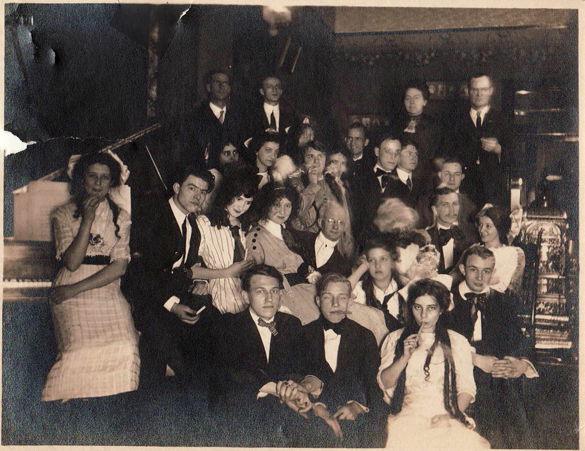
One of My Omaha Obsession friends shared: “I lived in three different apartments there. It was fab in the 1970s . Remember kids, “low rent” was once a minor insult, now it’s aspirational. Mr. Sweeney had the place when I moved in. He was a cranky old guy, but he was ours. The collection of hippies and students kept him mighty crazy. We partied a lot. The joint was always jumping. The people who owned it just before I left were called Lindhorst, they didn’t like any of us, but their children loved all the kooks and visited everyone when the clan came in from Millard to fix something.”
My friend Mimi Hahn reported: “My dad either managed that property or owned it a long time ago. I was 23 years old. There was a tenant named Eric that lived on the main floor, and he had a grand piano with a HUGE candelabra on top in the front window. You could see it from the street. I’ll never forget it. I think the rent was around $400 at the time. It’s too bad it is in the condition it’s in now. The city code list would be a mile long to restore and expensive. It’s a shame to see it go by the wayside.”
My dear friend Alfie Allen remembered: “I lived directly across the freeway from this lovely edifice at 2901 Jackson, which is no longer there. I had several friends that lived there throughout the 70’s and 80’s. I was in two different apartments that were spacious with high ceilings and lots of windows. It’s a building that I have always had a particular fondness for, and I am happy to see that Miss Cassette is on the case, as it were! I knew a wonderful hairdresser in the day named Marsha (last name escapes me, went to see Ike and Tina Turner with her, has tragic circumstances) and the other person was a good friend who became a chef named Marc Oswald. He was from Omaha and graduated from Creighton University the same time that I did and was very cool and quite handsome.”
Theory Development Part One
I submit this previous black and white photograph labeled Twenty-eighth and Howard Streets, as it provides a historical depiction of the buildup in this neighborhood, with remnants still observable around our 563 South Twenty-eighth in 2026. Without a doubt 563 was a considerably larger, more opulent, and more costly structure than the neighboring residences. In today’s terms this phenomenon is referred to as overbuilding. Mrs. Kaufman was unaware that this excessive construction would transform into a predicament, as the building’s scale, cost, and attributes were incongruous with those of the neighboring properties, which had yet to be established. She was enhancing Omaha and contributing to the blank slate. Sadly this glorious structure would depreciate in value over time due to the subsequent neighborhood buildings that were then demolished and the pricing of the smaller, lesser quality buildings that replaced them. Economic obsolescence, characterized by the degradation of the building’s worth due to its proximity to smaller residences, was exacerbated when the Interstate was constructed. We have already touched on the pocket of somewhat neglected lots and homes that we see today.
Briefing
From the 1910s until its demolition in the late 1980s and early 1990s, the Warren Apartments, situated at 515, 517, 519, and 521 South Twenty-eighth, combined with a small apartment above the carriage house at 521 ½, was a perfect fit between the large Richardsonian Romanesque building and the flats to the north on Howard.

White arrow points to the Warren Apartments, still standing in 1980.
569 South Twenty-eighth, also known as 571 South Twenty-eighth Street, was constructed on the substantial lot previously owned by 563 South Twenty-eighth. This MCM unadorned, puny-windowed structure was erected about 1953, on Lot 17. I have not dug into when Lots 17 and 18 were split but it happened after the 1930s.

Black arrow points to 571/569 South Twenty-eighth Street.
The early to mid-1960s saw the construction of Interstate 480 through the neighborhood, resulting in the removal of a whole city block, including the west side of South Twenty-eighth Street, homes bordering Jackson Street on both sides, which was also removed in this area, and the east side of South Twenty-ninth Street. The Interstate would certainly impact numerous other locations throughout town, but this segment is our primary emphasis today.
Jackson Tower, located at 600 South Twenty-seventh Street, was constructed by the Omaha Housing Authority between 1968 and 1971. Initially regarded as “low-rent apartments for the elderly” in 1970, the Jackson Tower, one of five buildings of its kind, was finalized in 1971. The wider transition from exclusively senior-focused, “single-demographic” Mid-Century high-rises began in the 1980s and 1990s as OHA initiated the provision of “mixed-income or general low-income public housing to address funding shortages, rising maintenance costs, and high vacancies.”

Severely distorted, however this indicates some degree of proximity. The black arrow indicates OHA Jackson Tower, located near the intersection of South Twenty-seventh and St. Mary’s Avenue, specifically at 600 South Twenty-seventh.
In the early 1970s two brick apartment buildings was demolished on the South Twenty-seventh Street side, adjacent the Jackson Tower, following the Omaha Housing Authority’s announcement of their acquisition of the area for the construction of a 15,000 square foot office building and parking lot. The address 540 South Twenty-seventh Street was to feature an entrances and parking lots on both Twenty-seventh and Twenty-eighth Street for their new office development. I see this as an additional fatal blow to the block, further casting it into a no man’s land of fragmented parcels and discontinuous lots.

East elevation facing South Twenty-seventh Street.

L-shaped western elevation, facing Twenty-eight Street. Large parking lots on both east and west sides of the building.

1974: The 15,000 square foot building was designed by Ambrose Jackson (hard blink to see the serendipitous name AMBROSE) and was selected to be next-door with the OHA’s Jackson Tower. Built by Vacanti-Randazzo Construction. A quiet neighbor, really, this is how 540 South Twenty-seventh has looked all of these decades; austere, stark, unembellished. Camera faces east on South Twenty-eighth. Its property was mowed and maintained.
As for our 563 South Twenty-eighth Street, the apartment building would change ownership hands multiple times over the decades. No longer furnished apartments, it appeared the building retained nine units spanning 13,570 square feet through these years of 1960s-1980s. In the late 1980s it was typical to find five of the nine apartments vacant. There were also attempts to rehabilitate the historical structure at some point. If you lived in this building or owned this building, we would appreciate your insights. I would love to incorporate additional photographs or interior images, if anyone is willing to share.
The property was listed for sale in 2001, after which its real estate listing was withdrawn. Dennis W. Marbell ultimately sold to Timothy L. Tvrdy for $100,000. It was listed in 2004, subsequently deleted, re-listed, and then removed again in 2005. I observed this pattern repeatedly. During this period, renters continued to occupy the premises, but with as few as two or three individuals residing in the entire structure. That had to have been so cool! The 2005 City Directory indicated that a married couple resided alone in Apartment #33—the whole building to themselves. The last occasion I found tenants listings was in 2006. From then on, the building was no longer rented. Boarded up years prior, by 2012 the address had fallen off the books. Restoration Exchange Omaha (REO) hosted their annual “Heart Bomb” effort at the 563 South Twenty-eighth Street apartment building in an attempt to highlight and advocate for its preservation. It didn’t seem to work.


Both images from the Reconnaissance Survey Photos (2011).

In better days.
Background Checks
I noted the 563 South Twenty-eighth Street building property had two parcel IDs: 2101570003 and 2101570005. This was new and distinct and was a flag. Properties are often subdivided when someone intends to develop or plans to sell in partial sale or phased development of larger projects. The smaller plots give the most flexibility in planning. I inquired about that. I reached out to the Douglas County Assessor/Register of Deeds to retrieve property record transfers for these parcels, and that is where I obtained the following information. All information I provide is derived from publicly accessible property records.
The trouble I was having in uncovering recent activity of the new owner was possibly by design. It should be noted that certain properties were either divided and/or combined after the acquisition. The history was hard to find from previous parcels, because they are now inactive. The majority of parcels appeared to have been acquired in 2016 from Luther Properties, Inc. Luther Properties Inc was under the management of Arlene A. Luther and Luther Properties. It was Luther Properties who amassed the adjoining parcels but the following LLC would further subdivide.
The following parcels were transferred on 07/14/2016 from Luther Properties Inc. to A. Towns LLC. This was a multi-parcel sale for a total of $834,500, which included the following parcels:
563 S. 28th St. parcel 2101570000 (that parcel is now inactive, changed to current parcel 2101570005 after sale)
569 S. 28th St. parcel 2101580000 (that parcel is now inactive, changed to current parcel 2101580003 after sale)
515 S. 28 St. / 2717-2727 Howard St. parcel 2102020001 (that parcel is now inactive, changed to current parcel 2102020007 after sale)
2722 Howard St. parcel 2102000000
Other parcel transfers:
2720 Howard St. parcel 2101990000 transferred 10/21/2020 from Habitat for Humanity to Andrew Towns LLC for $1,000
515 S 28 ST (is actually the parcel address of the below addresses)
2717 HOWARD ST
2719 HOWARD ST
2721 HOWARD ST
2723 HOWARD ST
2725 HOWARD ST
2727 HOWARD ST
The Andrew Towns LLC is held in a different individual’s name. This LLC has multiple businesses in two states. The LLC type is a “Foreign LLC,” date filed in May of 2016, before buying the bulk of Redicks addition parcels. A foreign LLC is a Limited Liability Company that is legally registered in one state but wishes to “transact business” in another state or jurisdiction. The phrase “foreign” pertains not to being in a different country, but rather to another state within the United States. An LLC must officially register with the business entity filing office of the new state to be recognized as a foreign LLC and function legally in that state. A domestic LLC is established in its home state; if it conducts business in another state, it is classified as a foreign LLC. If this is legal and above board, the owner resides in Colorado and may perhaps spend some time in Omaha. I can see they own other property in Midtown where they may stay or rent out.
Theory Development Part Two

Why the smoke and mirrors, you ask? In light of this information, it would appear the 563 South Twenty-eighth Street building is in deterioration due to the owner’s neglect. This is a long game in which landowners acquire separate, adjacent plots legitimately and await the emergence of a development projects. Or is this owner waiting to launch their own development? We have seen this before where other owners attempt to assemble plots for future construction. Greedy and harmful (when it comes to leaving historic buildings to moulder), this practice is entirely lawful. Intentional neglect of a building, commonly termed “demolition by neglect,” is the deliberate failure of a property owner to uphold maintenance, resulting in deterioration to a level that renders the structure hazardous, ugly, or irreparable. We have witnessed this game many times in Omaha where we are supposed to be grateful that an old, shabby building was razed because, “see…it had become an eyesore.” One might think the owner is trying to get around historic preservation laws but alas this structure lacks any protective designation.

Recent aerial map. The yellow outlines the Andrew Towns LLC properties, the majority of parcels subdivided as discussed earlier. Let me drop in here that there are other owners who have gathered multi-adjacent parcels in the area as well.
Please examine the site outlined in magenta on the map, which is a newly consolidated lot following the demolition of 528 and 532 South Twenty-seventh Street.
Let us now examine the recent developments at 540 South Twenty-seventh Street. By 1975, the Omaha Housing Authority was functioning from their office building. This was the location of OHA meetings and hearings for decades. It appears they concluded their affairs and I could not find much about their operation past 2011. In 2015, they acquired the former United Way of the Midlands facility located at 1805 Harney Street.


In March of 2024: Ad Meliora LLC entered a “remodel residential” on 540 South Twenty-seventh Street to the tune of $473,000. The Lund-Ross Construction sign has been on this building a long while. Fences went up, dirt was moved around on the South Twenty-seventh Street side, the grass has grown.
The property is owned by AD MELIORA LLC (means “toward better things” in Latin)
Principal Office Address:
2566 FARNAM STREET
SUITE 301
OMAHA, NE 68131
USA
Registered Agent and Office Address
GEORGE B. ACHOLA (real estate development attorney)
1004 FARNAM STREET, SUITE 400
OMAHA, NE 68102
Mr. Achola may merely serve as an attorney for this LLC. George Achola is also vice president of Burlington Capital Real Estate. Of note George Achola served on the Omaha Housing Authority’s Board of Commissioners for approximately two years. He is also a board member of inCOMMON, an organization that has been known to preserve historic Omaha buildings in order to create affordable housing for neighborhoods.
Is it possible that affordable housing is being constructed on the area between South Twenty-seventh and South Twenty-eighth? Could this entity acquire and renovate Miss 563 South Twenty-eighth Street under these circumstances? I firmly contend that if this area is to become a new housing complex, 563 South Twenty-eighth Street would and should serve as a central aesthetic anchor. If this is the opposite–a high-density “luxury”plan with out of reach rents, may I also make a case for saving Miss 563 South Twenty-eighth Street. Renovated and made beautiful again, 563 could really leverage the area’s original “historic” aesthetic. Please save 563 South Twenty-eighth Street.
With love,
Miss Cassette

A Queen-Size Gothic.

I welcome your feedback and comments on the fascinating 563 South Twenty-eighth Street. Please share your additional clues to the story in the “Comments.” Everyone would love to read what you have to say, and it makes the sharing of Omaha history more fun. If you have photos that you would like to share, please make contact. You can use an anonymous smokescreen name if need be. We want to hear from you.


If you like what you see, you can keep up with my latest investigations by joining my email group. Click on “Contact” then look for “Sign me up for the Newsletter!” Enter your email address. It will then display “Thank you, your sign-up request was successful!” Make sure to check your email address to confirm. You will get sent email updates every time I have written a new article. Also feel free to join My Omaha Obsession on Facebook.
Please share this investigation with others.
Thank you, Omaha friends.
Miss Cassette
The Demolition Arrived Before the Verdict
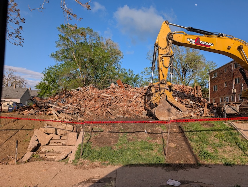
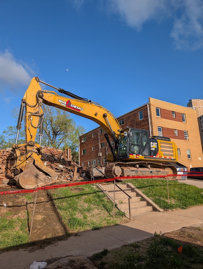
**Addendum of April 26, 2026. My friend, Jimmy Kaufman, captured these images. The end came with the usual bureaucratic efficiency that so often attends the destruction of old buildings. By April 17, 2026, the necessary permissions had assembled themselves into a tidy little firing squad—DCHD correspondence, NESHAP application, M.U.D. letter, asbestos checklist, pest-control approvals—all the modern paperwork required before a century-old structure may be politely erased. Demolition was completed during the final week of April, and by May 6 a “Clean Hole Inspection” had been performed, which is perhaps the bleakest phrase in the entire preservation vocabulary: a clinical confirmation that the building, having finally surrendered its last brick and memory, had been made satisfactorily absent.

My old apartment building on South Twenty-sixth Avenue. The Jackson Tower is seen in the distance. I could hear the fire trucks and emergency vehicles racing to the Tower at all hours of the day.


I should like to move in to 563 South Twenty-eighth Street. This will be how I decorate my room.
Dedicated to my soul brother, Jack France.
© Miss Cassette and myomahaobsession, 2026. Unauthorized use and/or duplication of this material without express and written permission from this site’s author and/or owner is strictly prohibited. Excerpts and links may be used, provided that full and clear credit is given to Miss Cassette and myomahaobsession with appropriate and specific direction to the original content.

MY aunt lived around the corner from 563 s 28th at 2707 DEWEY I THINK. WE LIVED AT 28TH AND WOOLWORTH.
Thank you, Charles! A bit south-you were in a nice bonafide neighborhood. I lived on South 26th Ave, directly east of the 563 apartment building. Loved the area. Always an adventure!
I’d recently found myself turned around trying to get to the newish Site 1 Brewery on Farney Street with all the contruction. Seeing as the Bridge was out over I-480 to the West I’d quickly turned my wagon south and then east, into the stark neighborhood just South. A flood of memories washed over me: I’d remembered these streets from childhood. My Maternal grandmother would drive her sister home from gatherings, or shopping to the nearby Safeway grocery as her sister did not drive, and us boys would be in the back seat along for the ride. Her home was long-gone, an empty lot, she herself had passed many years prior. I’d known her to walk to the close-by St.Peter Church and served diligently for years as a member of the Altar Guild there, cleaning and arranging floral displays. I’ll not list names, as even her only two sons have also passed. As I wound my way through the jumble of tight streets – going up wrong-way on the One-Way streets with no cares- I thought about all those lives lived among the remaining structures, or in previous homes on those streets, walking the sidewalks that still (somehow) remain. And I became emotional seeing all the loss on that dreary, dismall day, just last month. The only bright spot was the sole Sister, brightly painted, standing firm among the sad landscape. I wish her -and our Beauty, you so reverently detailed here – a long and happy future in this gentle neighborhood I’d remembered. Thank you 👹
You have taken me to the dreamworld of your memories. I don’t want go back to work! Thank you, friend dreamer.
What a fun and informative investigative journey into the past! While Omaha never had an enormous number of attached houses, it did have more than many cities west of the Mississippi and some of the best examples are in this general area of town. Many thoughts have come to mind regarding these three town houses but time allows for just a few this morning.
More than a century of changes and neglect have eroded the appearance of these fine houses—leaving less to consider when attempting classification. Despite alterations to the front porches, several pilasters (halved columns or posts) remain affixed to the brick walls at each of the three entries (as seen in several of the photos). These pilasters aren’t just great clues as to what the porches originally looked like, but they also help to narrow the place stylistically. The lower portion of each pilaster is lathe-turned in classic Queen Anne style while the upper portion is not (these upper portions likely once anchored ornamental wood spandrels between the posts). In short, the original porches were very fussy, very prominent and relentlessly Queen Anne.
While the façade in question does have strong Chateauesque and Richardsonian Romanesque influences, Queen Anne porches are not characteristic of either of those styles. Porches in those meatier styles, when they occur, are of masonry and decidedly more substantial. Queen Anne is an inherently eclectic style and these houses can rightfully revel in being strong examples as expressed in the town house form. I share your hope that they can be saved and respectfully restored as their continued presence can only benefit Omaha. Thank you for your dedicated detective work!
Thank you for this. I have learned a lot from you. We need earlier photos. I hope someone comes forward with something
Growing up on the corner of 31st & Pacific, I was aware and appreciative of the assorted architectural styles in and around my neighborhood. I can only imagine the types lost to time when I-480 went right through the middle of Sheelytown.
Once again you have provided an entertaining, educational and historical voyage through time and space. You are a gift. Thank you!
https://www.nytimes.com/2026/02/17/realestate/mysterious-ditmas-park-mansion-1000-ocean-avenue.html?unlocked_article_code=1.NFA.G82u.-Sv8b1QKUTTA&smid=url-share
Thank you for all your work. I grew up in the Field Club area then moved to District 66, loved your articles on Field Club and Loveland. Love old homes too. Was a good friend of Melanie Walsh, Andy Holland and Susie Buffett. All nice gals. Their mothers were all very kind too.
Well, enjoy this article. And keep ‘em coming!
Just finished the 563 28th street blog. Loved the Dogs in Space reference. Probably my favorite punk movie.
One night around 88-89 I was driving north on Park Avenue and was stopped at the light at Leavenworth when a man and a woman came dashing up Leavenworth and jumped into the back seat of my car , laughing and telling me to go, go ,go. They started pulling out cough syrups and other assorted over-the-counter medicines from their coats that they obviously had just shoplifted from Kohll’s. After the man offered me the services of the woman, (I declined as I was going to my girlfriend’s apartment) they directed me to drop them off at 563. With a hearty “HAPPY NEW YEAR” they dashed inside.
Strangely this wasn’t the only time someone jumped in my car and demanded a ride but that’s another story. Thanks for another great article and happy 10th Anniversary!
It is an eclectic building, but I think that it is closer to Queen Anne than anything else. The prominent 3-centered arches on the facade and the use of ablaq in the voussoirs are both seen in Queen Anne. It would be surprising to find a real Richardsonian Romanesque building that did not have a least some prominent round arches of the normal Roman type. Thanks for doing all of the work on this!
563 South Twenty-eighth Street was demolished this week. Way to go Omaha! Continue your journey of methodically wiping out history.
Oh Howard! I was alerted to that. About to upload the photo.
Thanks for sharing this historical journey of the area. I really enjoyed this.
Thank you, Lynn Ann!