Yes, Omaha, The Writing’s On The Wall all around us. Progress is underway and cannot be impeded. We must enhance and expand! Today we are breaking with tradition and will aim to tackle two little investigations concerning impending demise: 35th Avenue to 36th Street on Leavenworth and 42nd and Pacific.
Case Number One
There exists an unassuming, little, cinderblock structure at the northeast intersection of 36th and Leavenworth Streets. 3572 Leavenworth Street, to be exact. I am certain that you have all observed it; some of you appreciate it, and many of you have shopped or dined there. Most recently it has been home to Taste of India where someone saw fit to literally write on the wall that change was afoot. A while back I received an entertaining message from a My Omaha Obsession reader, Robert E. “Bobby” Wilkerson, who provided an antiquated matchbook from a shop that long ago occupied the corner. Like many of us who resided in this neighborhood, Bobby dedicated a significant portion of his life roaming up and down Leavenworth. Another passion of his is matchbook collecting…and what a collection he must have.

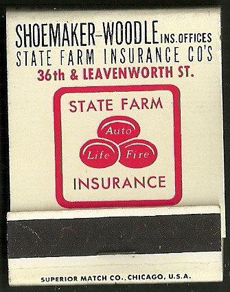
Bobby detailed that he was “tickled to death” to discover this newest matchbook because of its clever depiction of THAT BUILDING. He stated, “I normally think insurance matches are rather boring but this one is different. I think I remember the building when it was the insurance office, but I also remember it as a Go Big Red store and I even remember getting some tacos there at a very short lived joint in the 1990s. What do you say about it?”
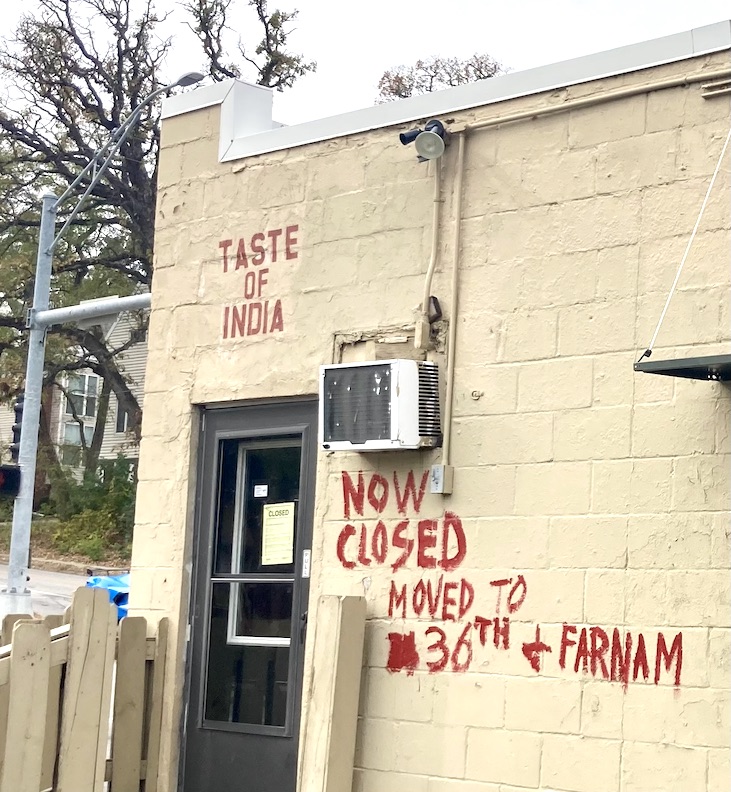
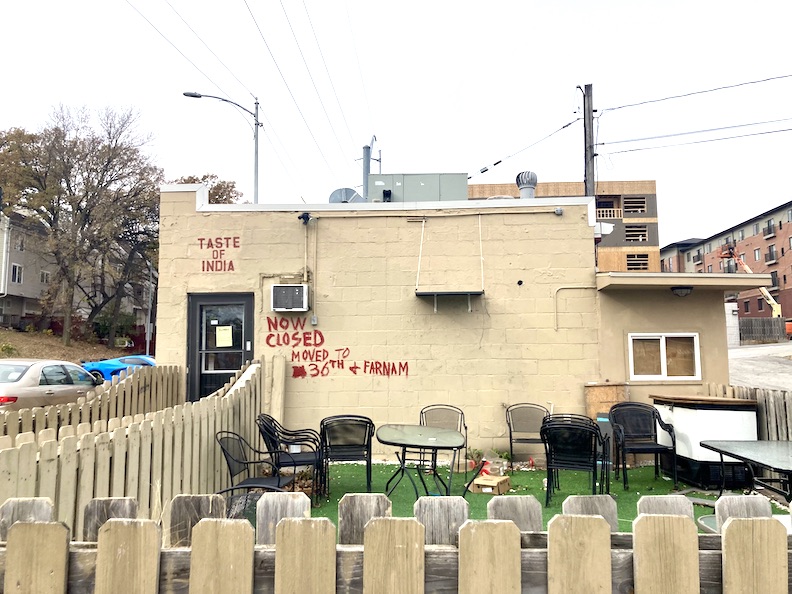
Upon learning that the recent occupants of the no-frills structure had hastily painted that they were CLOSED with their soon to be new address on the exterior wall, I concluded that the moment to share this investigation had sadly arrived. This mini inquiry goes out to Bobby Wilkerson.
Early History
Mr. John S. Caulfield arrived in Omaha in 1866 and entered the book and stationery business, continuing until 1892 when he sold to the Megeath Stationery Company. The Megeath family is Omaha Famous around our detective office and if you lurk around with us often, you’ve heard the name. Mr. Caulfield left the book trade to concentrate on his real estate holdings, which included multiple farms and innumerable city lots, as well as travel. He was a single man, never married, no identified relatives in Omaha. Tracking his real estate transactions was not difficult. In 1886, John S. Caulfield transferred ownership of Lots 5 and 6 in Block 13 of the Isaacs & Selden addition to one David H. Bowman. Mr. Bowman also was known as a prominent real estate investor in Omaha, acquiring properties under his name and his firm, Bowman Real Estate. He possessed commercial, residential, and undeveloped properties.
While traveling in Chicago in 1902, our Mr. Caulfield “dropped dead.” The newspapers of old loved seemed to favor blunt phrasing such as this. There were some reports that while waiting for a train, Caulfield was “stricken” at the railway depot, which I initially took to me he was hit by a train but other reports would make clear he died of heart failure. Evidently heirs did materialize, although not living in our Omaha. Because his successors were unable to agree on a division of his property, about twenty lots, which were but a part of his massive estate, were sold at the courthouse to several unknown purchasers.
Based on my analysis of the historical DOGIS aerials of 35th Avenue to 36th Street on Leavenworth, this block contained around five to six houses prior to the construction of our cinderblock building at 3572 Leavenworth Street. David H. Bowman would sell these homes and many other parcels over time.
For more early history of this wonderful part of town, check out my earlier investigation: Mysteries of Omaha: The Mansion in the Trees.
Harry B. Watts
Harry Bennett Watts was born in 1891 in Oskaloosa, Iowa and as a young man, served in World War I. Mr. Watts entered the entertainment industry through theater management during its era of prestige. Omaha once had many fabulous theaters. I noted he managed only the toniest of them often rivals, specifically The Strand, The Rialto, The Riviera and The Paramount. (What is now known as the Rose Theater opened in 1927 as The Riviera. It was then named The Paramount in 1929, then the Astro in 1962, then The Rose Blumkin in 1990.) I discovered these clues in the various Omaha City Directories from the 1920s and 1930s. Harry Watts subsequently met and wed Dorothy G. Sasenbery Watts in 1929 in Minneapolis, where Mr. Watts was operating a theater. There was an additional theatrical stint in Chicago. In this time the Watts couple had daughters Nancy and Barbara.
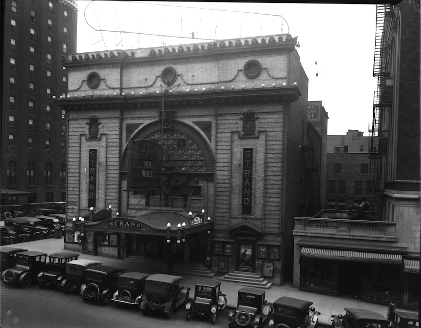
The Strand Theater at 1722 Douglas Street. Formerly the American Music Hall. Bostwick, Louis (1868-1943) and Frohardt, Homer (1885-1972. 1920.
Roxy Music says, “That’s why we say ‘Do the strand!'”
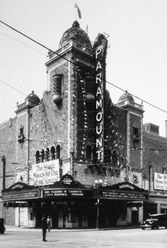
The Paramount, 2001 Farnam Street. Originally constructed in 1926. Ukrainian architect: John Eberson. Photo property of Durham Museum.
Mr. Watts became manager of the Muse Theater in 1945. For my earlier investigation into the Muse Theater, check out: Secret of the Muse Theater. Later that same year, Harry ventured into the doughnut business, branding his variant “Dunk In.” Pretty good, huh? By 1947 he was bemoaning the “lost dough” (his joke not mine) and was looking to try another operation.
I was pleased to discover this building permit from October 1947 for 3572 Leavenworth Street. Mr. Harry Watts constructed the modest cinderblock structure at approximately $3,000. Harry Watt’s Pet O’ Mine moved into the structure of his modest design in December 1947. Pet O’ Mine became the beloved pet store of Midtown and one of the oldest pet stores in the Omaha-Council Bluffs region.
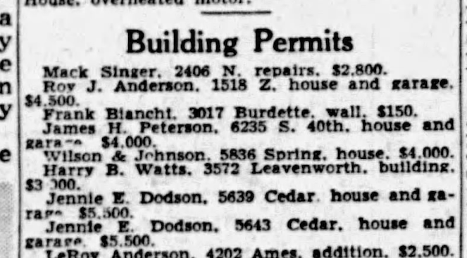
Evening World-Herald. October 2, 1947.
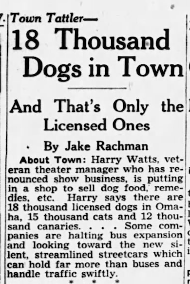
Evening World-Herald. December 8, 1947. Twelve thousand canaries….

Their earliest advertisement. 1948.
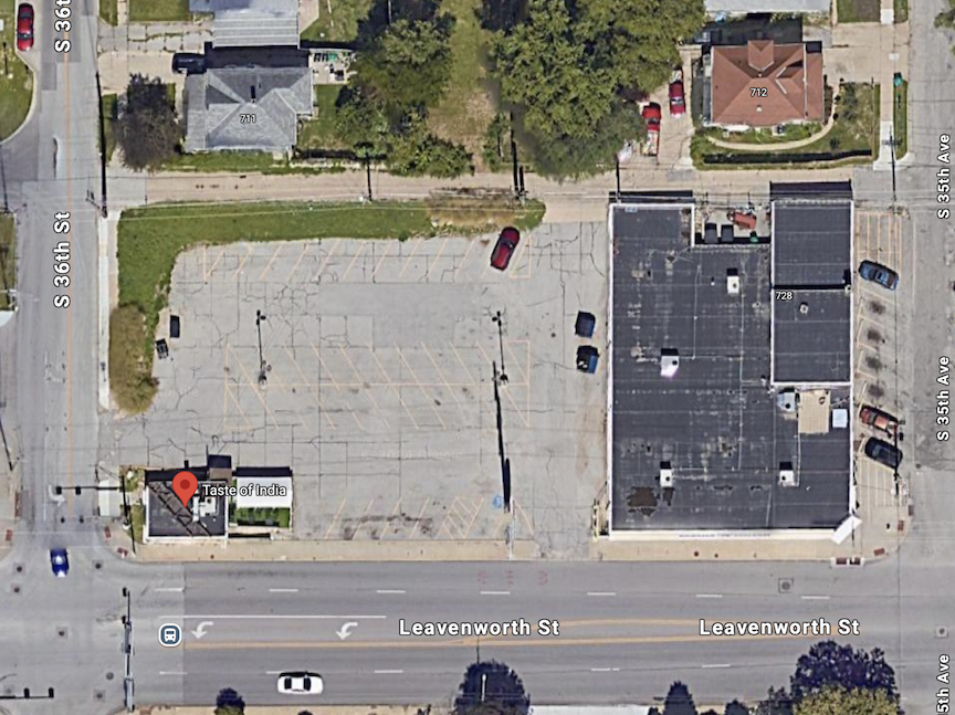
The Google red marker points to “Taste of India,” originally Harry Watt’s store.
Apparently by November of 1957 Harry Watts was packing up his Pet O’ Mine for 4018 Leavenworth, the location they are best known for. Everyone was moving west by then and perhaps 39th and Leavenworth offered him more space. By 1952, Wally Hein, the son-in-law, together with other family members, including Dorothy Watts, operated the cherished pet store. When Pet O’ Mine moved uptown, it was shoulder to shoulder with Bob McCormack’s infamous Playmaker Lounge and the Charlie Graham Autobody. Oh, the good old days of Leavenworth! Take me back. Playmaker Lounge would later become Pauli’s famous sports bar.
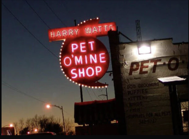
Antonio G. took this wonderful photo. Our only proof of the fabulous Harry Watts Pet O’ Mine sign and shop.
Wally Hein was a very warm man and lots of fun too. This is the location where I purchased food for my cats in the 1990s-2000s. On one occasion, Mr. Cassette and I were required to bring in our Bronwyn “Ninners” late night after she decided to play in the fireplace soot of one of our best apartments. (There was no fire in the hearth, don’t worry, just left over soot.) Oh my…Wally allowed us to come in after-hours and managed it with composure, while Ninners returned home exceedingly irate yet impeccably clean.
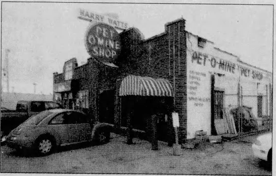
Pet O’ Mine closed in 2004. Pauli’s Blue Room (to the west) would absorb the rest of the building after Pet O’ Mine left. The whole brick building was torn down around late 2013.
Harry B. Watts died at age 68 in 1960. Dorothy Watts died in 1998. I was so sad to read that Wally Hein, manager of the store, died just a few years after closing Pet O’ Mine.
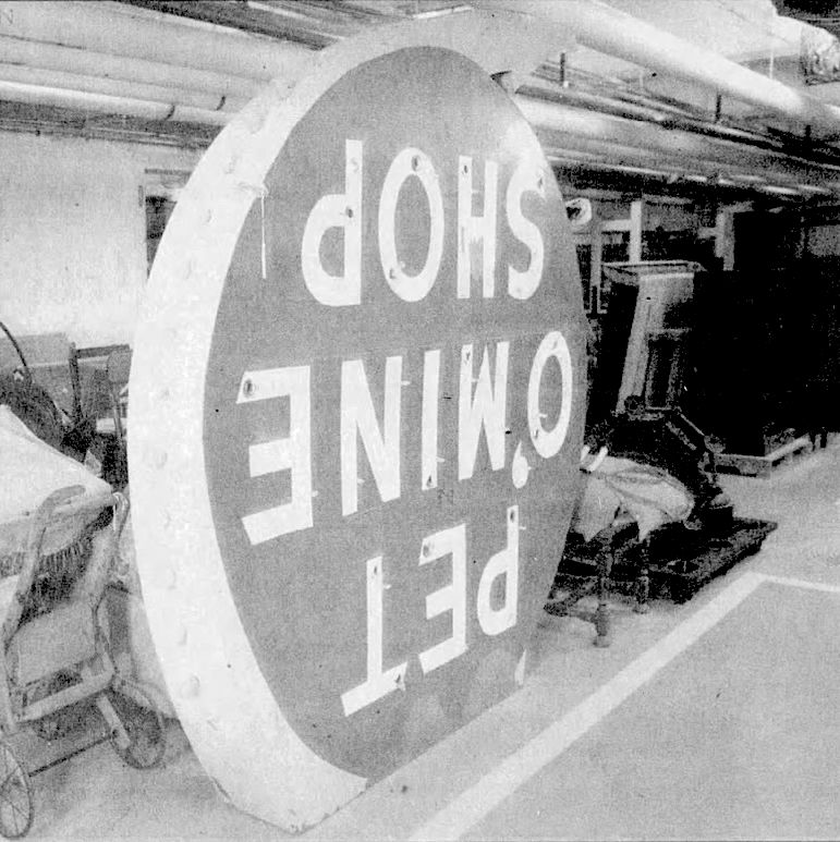
They say the Durham Museum is the keeper of the 7 foot tall Harry Watts Pet O’ Mine sign, rumored to have been created by the same person that made the La Casa neon sign.
Return to 3572 Leavenworth
While Pet O’ Mine headed west, the little building at 3572 Leavenworth sat empty for a while. State Farm Insurance would eventually take up the lease at least by 1958, in the hands of George Shoemaker and his partner, Robert Woodle. Shoemaker Woodle Insurance Offices at 36th and Leavenworth made use of the corner business into the early 1960s.
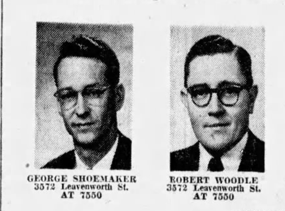
Here they are in April of 1960. A couple a real nice looking fellas.


It was during this time period when the two obviously created the matchbook design. Adore it.
If the little matchbook illustration of the building is anywhere near accurate, it featured a frontal entrance and two expansive retail windows. a front facing door and two large retail windows. There was no side door, although perhaps a rear entrance, out of view.
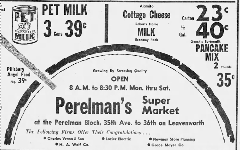
In around 1955 the Perelman’s Super Market was built at 35th Avenue and Leavenworth, (3552 Leavenworth) directly to the east. Perelman’s would clear the remaining houses on the block to create their large parking lot. In January of 1968 Tony’s Grand Central Market (a Spartan Store) would take up the reins for 3552 Leavenworth. The Grand Central Market remained on the corner until 1992.
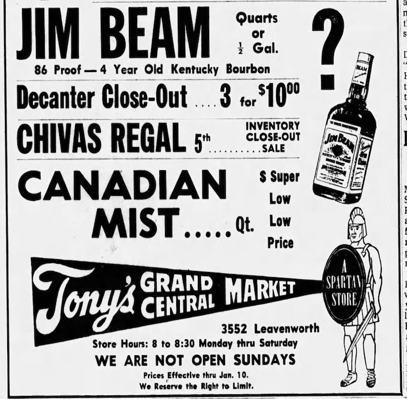
1970. Omaha World-Herald.
Does anyone remember the short-lived 11-Worth Flea Market in 1992 and 1993? Not long after, the Family Dollar took up the lease.
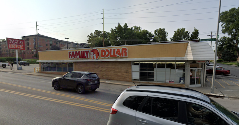
Not many alterations to 3552 Leavenworth. Classic, low slung, MCM grocery store with a corner entrance door, which I adore.
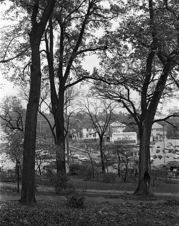
Although not a clear photographic shot, this remains a nice mysterious view. This 1963 photo taken from the once wooded mansion property just south across Leavenworth, one can see that the Shoemaker Woodle insurance office at 3572 Leavenworth had a prominent billboard on top of it. I got out my magnifying glass and it read John A. Gentleman, the well known undertaker in town. Peering through the trees also reveals the freshly paved parking lot of Perelman’s Super Market.
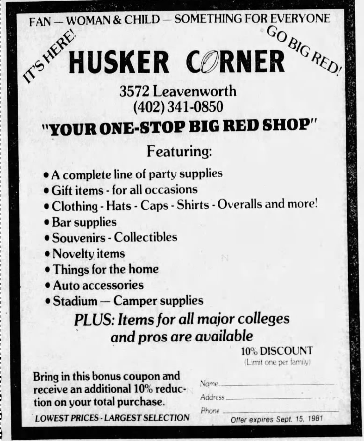
1981. OWH. Bobby was correct. Husker Corner moved into the store, after the insurance company had moved on. Now this seems like a good fit for that location.
I would discover a Z’s Corner Grocery in the tiny building by 1996.
Series of Restaurants
If I am not crazy, I seem to remember my girlfriend, Angel Holland, had a restaurant here. I think it was after she shuttered our favorite Dazy Maze veggie restaurant in the Old Market (521 South 13th Street.) Or maybe this was just a dream of hers that she shared with me. Am I way off? I can’t seem to find her these days to ask. Surely one of you knows. In 2007 La Tia’s Hot Tamales, an American Mexican restaurant transitioned to El Rebano Mexican Restaurant with different owners. Do you remember their tiny drive-thru?
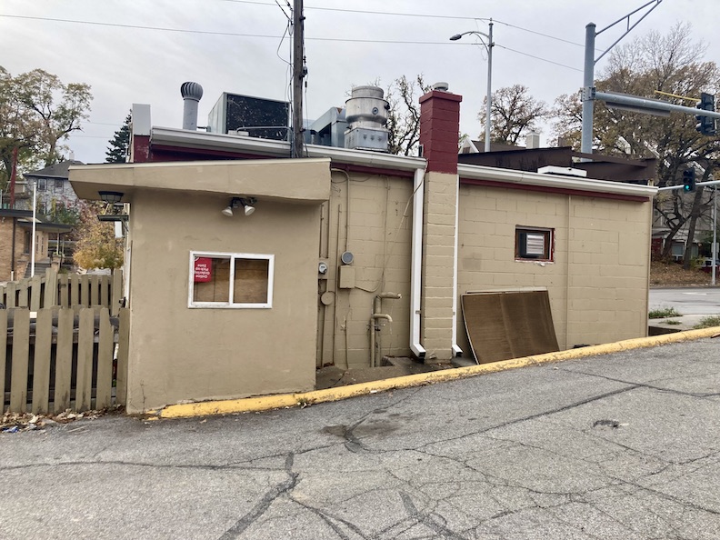
Remnants of the north side drive-thru, a later addition.
**Addendum of Nov 4, 2024** My Omaha Obsession friend, Janna Mattingly, just shared the best, weirdest photographs with me. She wrote: “These are pics of the odd painting on the door facing Leavenworth when the building housed the restaurant El Rebano, 11-07. Later the painting was revised to have a man stirring and a goat was in the pot.”
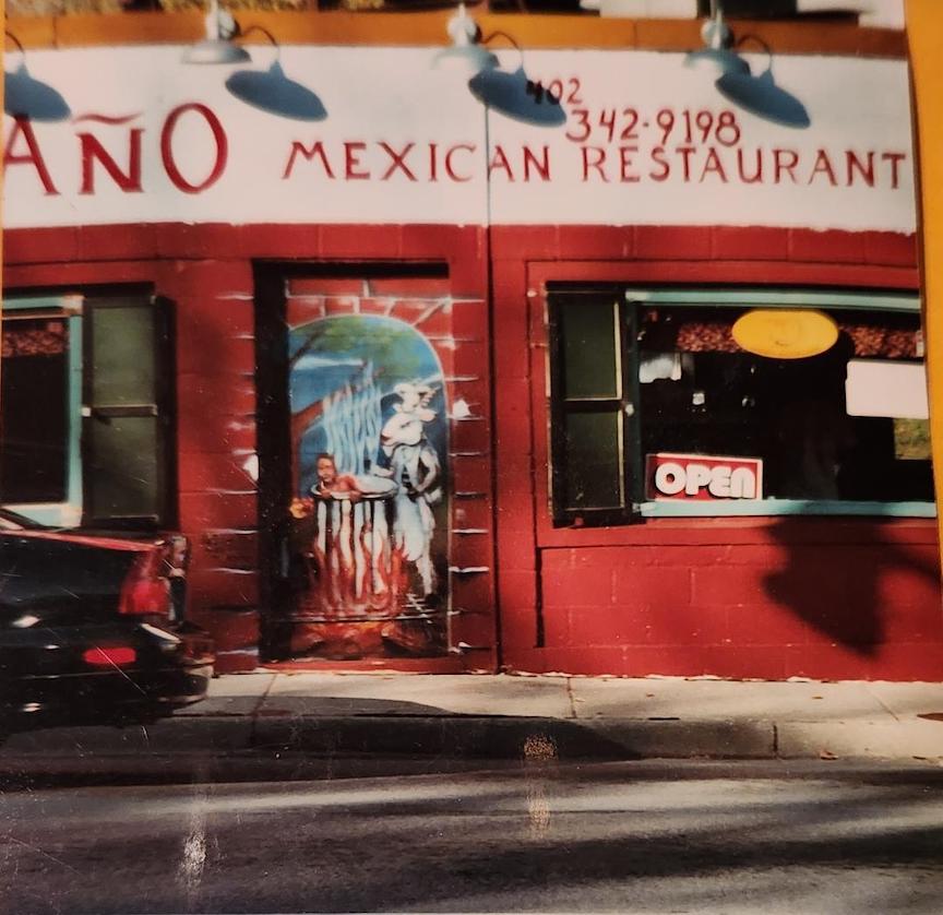
3572 Leavenworth when it was El Rebano Mexican Restaurant. Amazing colors and photo–it looks like a movie set!
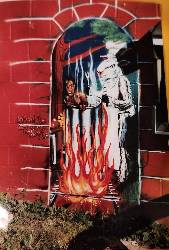
Detail of the 3572 Leavenworth El Rebano Mexican Restaurant.
WOW. Janna always captures/d the best photographs. Thank you!
Owner-chef Joseph D’Souza moved his establishment, Mother India, to the 3572 Leavenworth location in the winter of 2009. Joe, specializing in tandoori food, had been a cook at Omaha Famous Indian Oven. Mother India, with 18 seats, appeared perpetually full. We couldn’t get enough of the place and we weren’t the only ones.
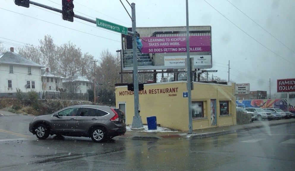
Natalie E. took this great little photo of the Mother India Restaurant in better days. Snowy days. Note the packed lot.
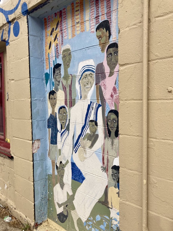
In the old doorway off of Leavenworth, Mother India commissioned a mural of Mother Theresa, which I always liked. Mother India closed in September of 2018, after the D’Souzas announced their retirement.
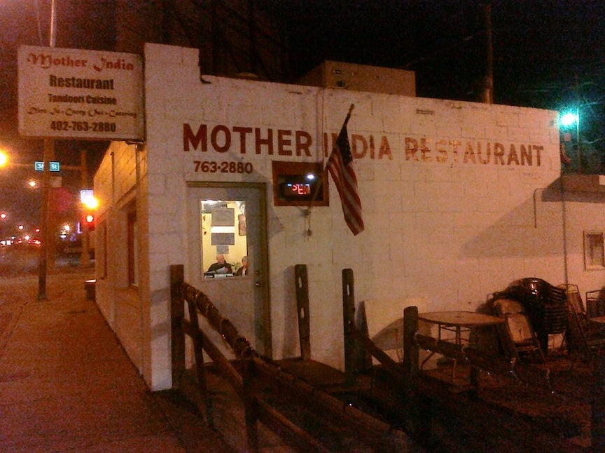
Steve Y’s great photograph from 2009. We loved the simplicity.
In 2018 the owners of The Taj Kabob and Curry purchased the Mother India location and moved in soon after. We had been big fans of the 114th and Dodge location in the early 2000s. They named their new restaurant Taste of India.
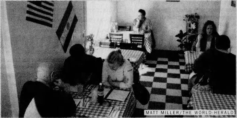
Interior of Taste of India in 2018. Omaha World-Herald photograph by Matt Miller.
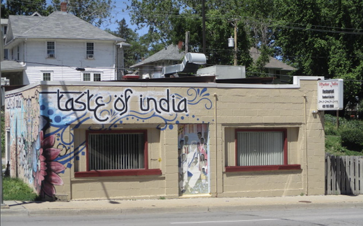
Leavenworth Street elevation. The front picture windows of the old store are apparent (now reduced in size), along with the front door directly accessible from Leavenworth, now boarded up.

West elevation mural.
According to their latest hand painted message, Taste of India was also headed west. We gathered from Nicole Buntgen’s reporting in Grow Omaha that Taste of India is relocating to 3562 Farnam Street in the former Farnam House Brewing Company space at 36th and Farnam in Blackstone.
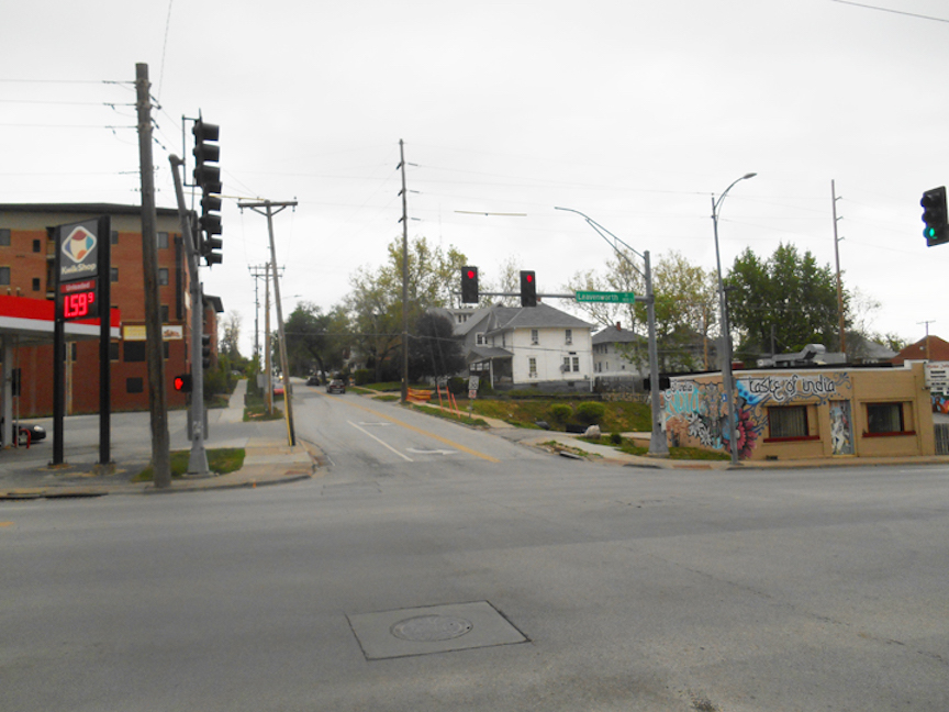
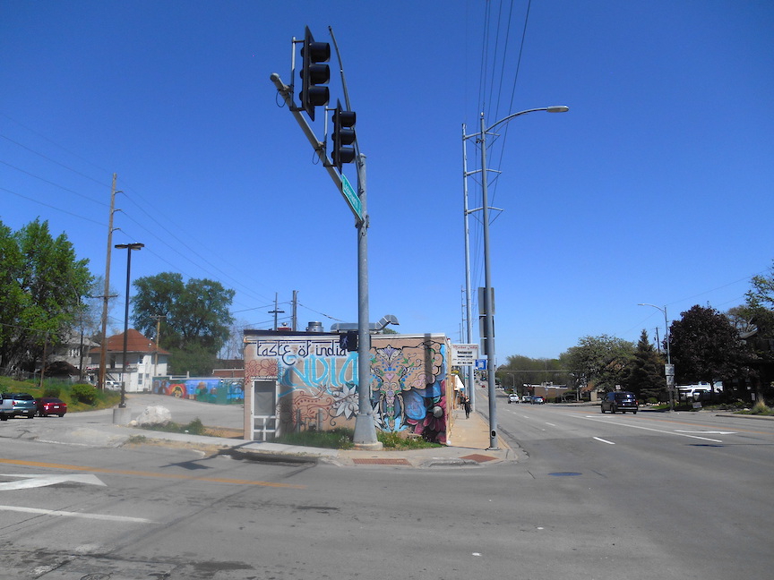
Taste of India photos I took back in 2020.
For the record, we wish Taste of India All The Best and cannot wait to check out their new digs.
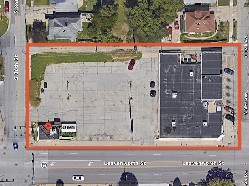
It should be noted at this juncture, as if it would surprise anyone, that at some point, the Family Dollar building and its parking lot, in addition to the Taste of India building was melded into one large parcel.
The Smoky Plans
In September 2022, the Family Dollar located at 3552 Leavenworth and a foursquare residence at 3559 Jones, situated directly north of the Family Dollar-Taste of India buildings and parking lot, were sold. The neighbors have suspicioned that the entire block from 35th Avenue to 36th Street along Leavenworth will be transformed into a massive mixed-use apartment structure as is the prevailing tendency in the area.
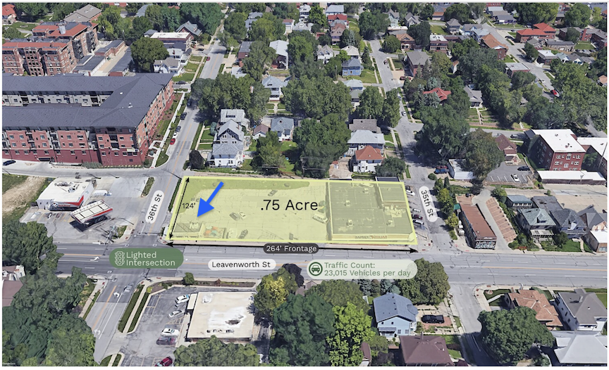
Aerial borrowed from Oak Investment. I directed the blue arrow at the Taste of India, 3572 Leavenworth building.
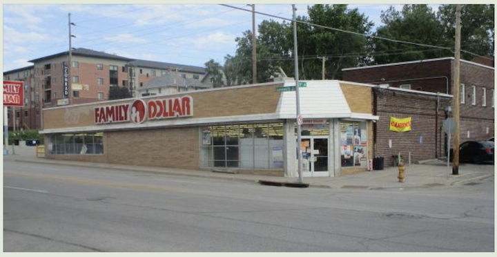
Family Dollar at 3552 Leavenworth, on the northwest corner of 35th Avenue and Leavenworth has been at this location since 1993. Image borrowed from Douglas County Assessor site.
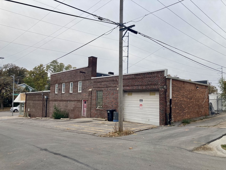
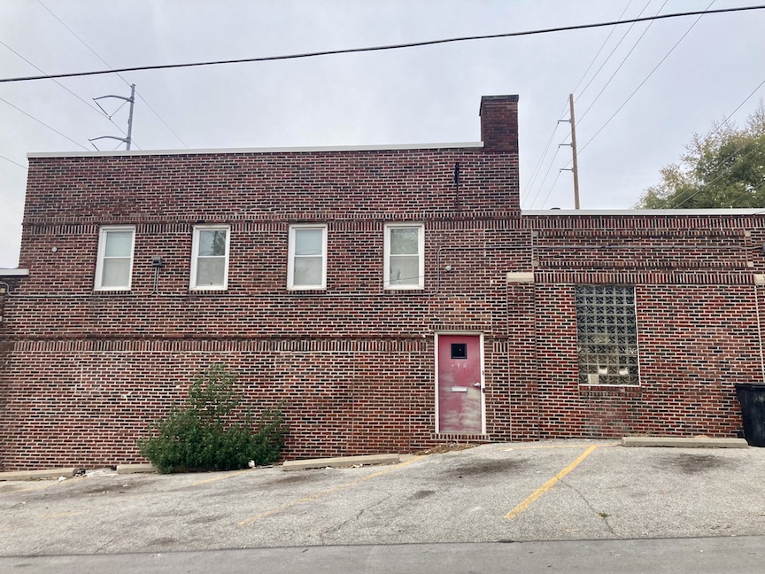
By the by, the Family Dollar is adjacent to a very cool structure at 728 South 35th Avenue.– Signs above the garage read “DiBar Enterprises.” I am in love with this building. I speculated whether this extra building to the north was a latter construction intended as an apartment for the Perelmans or as a rental unit for more revenue. Or was it always the same building? The extra mystery is that 728 South 35th Avenue exists nowhere on paper, however DiBar Enterprises functions under an LLC; Dave Bartholet is a real estate manager.
In the summer of 2023 an investment real estate brokerage, Oak Investment, bought the city block with three structures on Leavenworth Street and an additional house behind on Jones Street, under the name Leavenworth Land LLC. There are rumored plans to build a large apartment complex here. Oak Investment Real Estate.
Just the other day, October 28, 2024, The Daily Record released news from the City of Omaha Public Notices “Approval of the 3552 Apartments TIF redevelopment project plan, 3552 Leavenworth Street.”
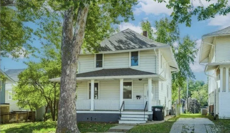
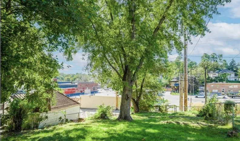
3559 Jones front elevation and backyard photo, showing clear access to the potential complex abutting Leavenworth.
I conclude that the properties at 3572 Leavenworth, which houses Taste of India, along with the Family Dollar, the 728 South 35th Avenue building, and the residence at 3559 Jones, will be demolished for the construction of a substantial apartment complex or mixed-use business on the ground floor, apartments above. The 3559 Jones will presumably function as the gateway of the new complex. Faced with this reality, Taste of India most likely made a plan to head for high ground in Blackstone.
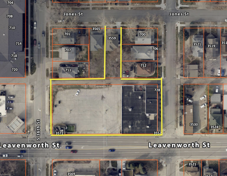
Aerial borrowed from the DOGIS site. I highlighted the boundaries of the new parcel, including the 3559 Jones property. It is easy to see that the 3559 Jones parcel would make a safe, alternate entrance to the new project, rather than Leavenworth access.
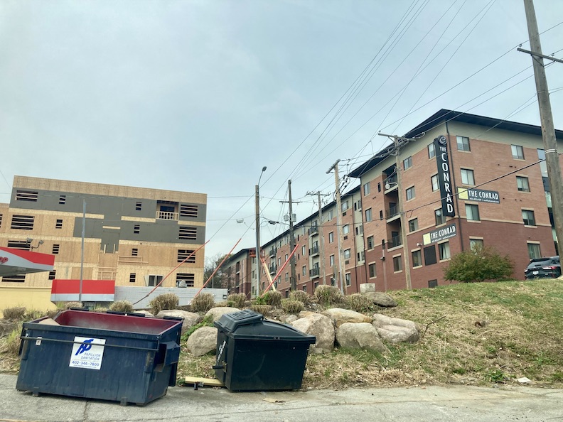
Here are the behemoth-sized apartment projects just to the west of Taste of India, across 36th Street. It ain’t pretty, kids… in fact, it’s downright soul stealing. But the following image makes it even more clear what is happening in this part of midtown…
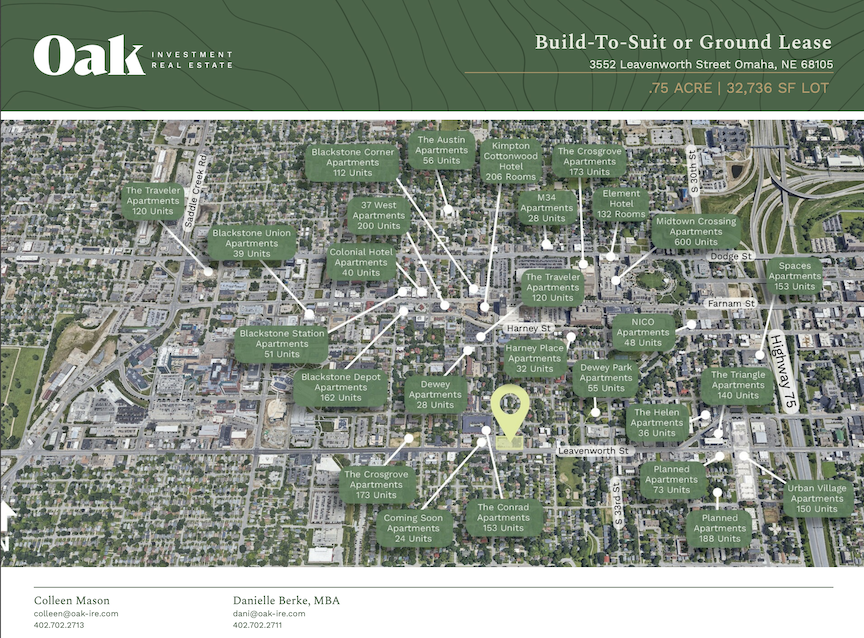
Image borrowed from Oak Investment site. This handy map lists how many massive apartment projects are in Midtown right now. In the future, we will see this expansion all across town, as individuals are persuaded (or forced because of lack of options) to rent rather than purchase from corporate landlords and national property owners. They hope the significant increase in mortgage rates, attributed to LLC and corporate ownership, will compel more individuals to seek apartment residences. The brilliance lies in the fact that these firms acquiring homes are simultaneously constructing massive apartment complexes or are working in tandem.
***This just in from Omaha City Planning. The project developer is 3552 Owner, LLC, managed by Ryan Spellman. Mr. Spellman was mentioned as developer in a recent article of mine: New Omaha: Tracing 50th and Leavenworth. All this to say, he is an exceedingly busy man with a love for Big Box Apartment Bins. As a side note, have you heard that Costco plans to build an 800-unit apartment building in Los Angeles and are looking to get into the residential rental market? It’s all coming together now, isn’t it. If Amazon intends to build these uninhabitable structures as well, the closed loop will be finalized, and individuals will not even express discontent about residing in a pod.
“The property is presently occupied by two structures; a vacant commercial building that was last occupied by a Family Dollar store, and a vacant former restaurant. The site will be cleared and a new five story apartment building with 85 market rate units will be constructed. There will be one level of structured parking inside the building. Proposed amenities include a lounge area, a fitness center, a private elevated courtyard, and pet amenities. The project will provide 58 onsite parking stalls within the apartment structure, and will provide one new stall along South 35th Avenue. Secure bicycle storage will also be provided.”
Does anyone else find it funny when applications to city planning and TIFF applications make a big deal about filling vacant business sites when the developers are the reason that the businesses had to leave? Vacancy on demand in order to flip a parcel to another developer seems silly when everyone can see what is happening. I mean, why pussyfoot around?
This is the comical portion of the TIFF application: “Simultaneously, multiple challenges including rising interest rates and inflated construction costs face housing developers and have brought an abrupt chilling effect on the creation of new apartment starts in Omaha. The project developer expects there to be significant demand for this project given its location and quality of design and construction.” Let me redirect you all back to the previous image borrowed from Oak Investment site, where many of the apartments illustrated remain unrented. Yes, no one wants to rent these new apartments but this is all a long game where developers know these Personal Depression Boxes will, in time, be the only option.
**Addendum of November 5, 2024** Oak Investment, under the name 3552 Leavenworth LLC purchased the Family Dollar property in 2015 for $603,000. Then the same 3552 Leavenworth LLC, Oak Investment bought 3559 Jones Street from Shawn and Amanda Wilson in 2018 for $110,000.
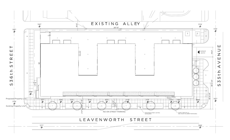
Plan for 35th Avenue to 36th Street along Leavenworth. ALLEY POYNER MACCHIETTO ARCHITECTURE

ALLEY POYNER MACCHIETTO ARCHITECTURE. Does this look familiar?
Now that we are sufficiently irritated or maybe pleased as punch, let us move west a bit to assess another tear down in progress.
But before we do–Do you love Leavenworth Street and want to know more? Here are links to my original Leavenworth Street investigation series. Clearly I am obsessed.
The Fabulous Fireside Connection
Magnificent Obsession: 1928 Leavenworth Street
New Omaha: 3802 and 3824 Leavenworth
Mysteries of Omaha: 812 South 42nd Street Part Two
New Omaha: Tracing 50th and Leavenworth
The Case of the Caretakers Mansion: 808 South 60th Street
Mysteries of Omaha: 5423 Leavenworth Street
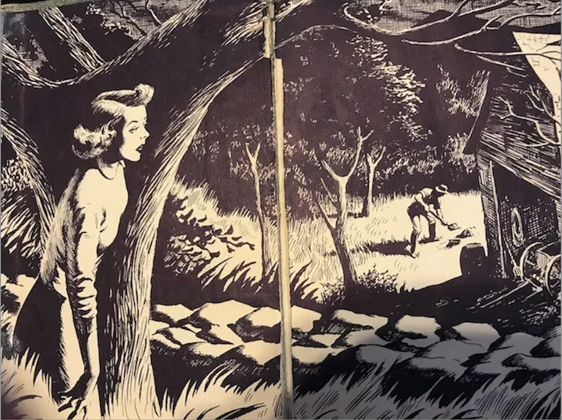
Case Number Two
42nd and Pacific Street Demolition
My Omaha Obsession friend, David Johnson contacted me to inquire about a structure being demolished at the northeast intersection of 42nd and Pacific. He stated that, at the time of his writing, the substantial brick building was almost 75% gone. David was aware that the building was owned by the county, but he was uncertain about its use. He remarked that the construction resembled military barracks. He wondered if I knew any history. Earlier in the week my friend, Bruce Karlquist, had also contacted me about the same building. Bruce also knew the teardown was a county building but wondered what the plan was for the soon to be empty corner.
I, too, had seen the workers hacking way at the poor trees on the property site. They left bizarre half-stumps as if a tidy tornado had whipped through. I had noted the ugly plastic construction barrier fencing around the perimeter. Yes, I had taken all of that in and then promptly pretended it was not happening. The Abandoned Mystery Grade School would forever stand in my mind. But as it turned out, I have been wrong about this great brick midtown structure for decades. No, it was not a deserted school.
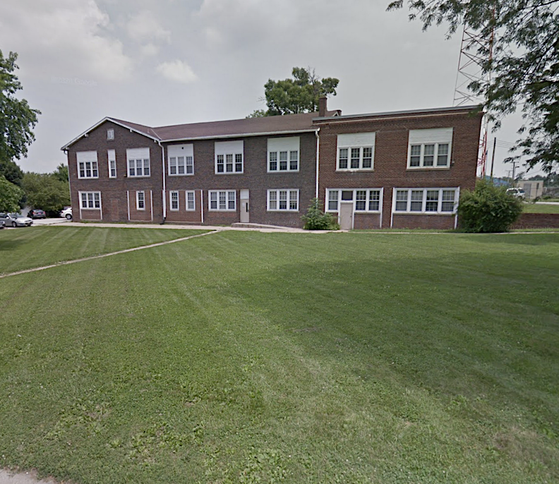
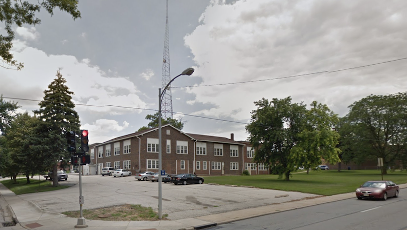
1101 South 42nd Street is a substantial building situated at the intersection of 42nd Street and Pacific. I used to Frequent With Fervor a thrift store around behind this structure to the east. My stars I love thriftin’ there– now, long gone. In all the years of parking back there, boys and girls, I have always assumed 1101 South 42nd Street was an old school house, no longer in use. I mean, look at it.
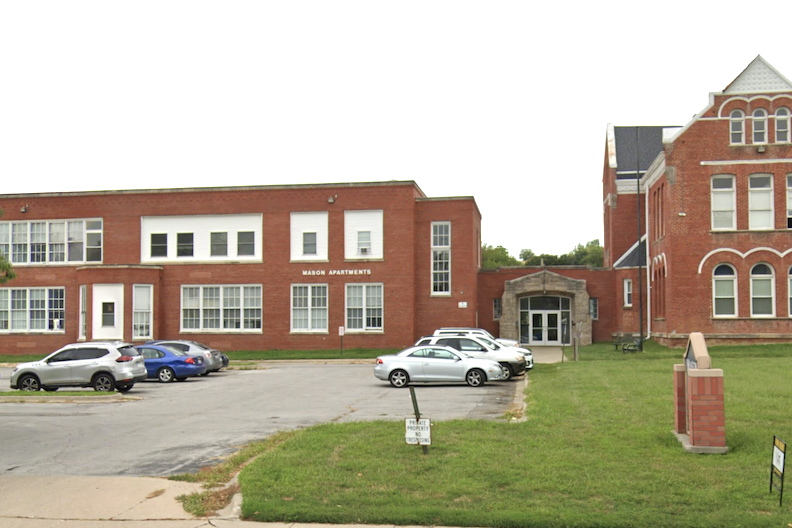
In my defense, I submit the Mason School, now apartments at 1012 South 24th Street. Similar, no?
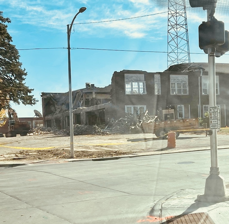
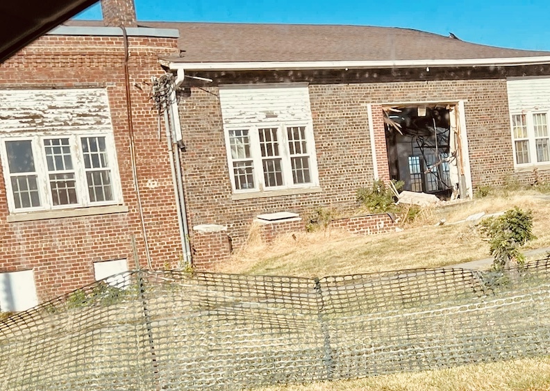
42nd and Pacific, 1101 South 42nd Street, to be exact. My Omaha Obsession friend, Bruce Karlquist, had sent over these images on October 25, 2024, when I was out of town.
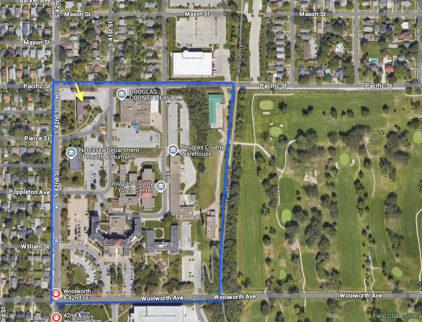
The brick building in question at 1101 South 42nd Street is located within the bounds of the Douglas County government buildings, outlined in blue. Marked by a yellow arrow, 1101 South 42nd Street was situated in the upper lefthand corner of the larger acreage. As if there were any doubt at this point, 1101 South 42nd Street was indeed (always) a county building. PS The enormous structure designated as Douglas County Health previously housed my favorite Goodwill Thrift Store, prompting me to question the rationale behind its location.
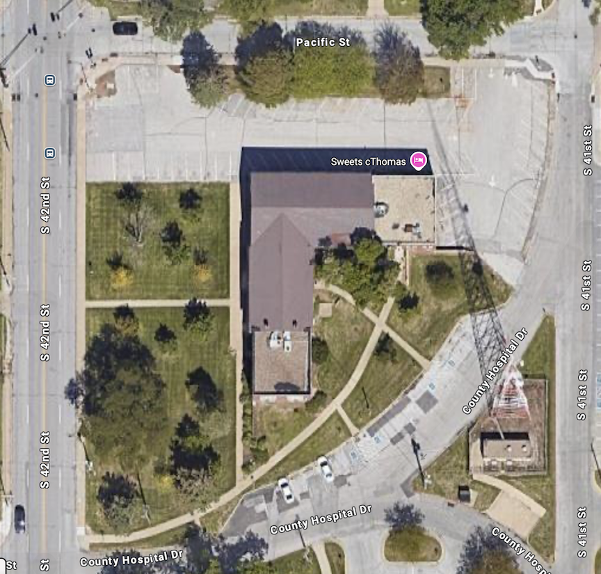
Enlarged aerial, allowing one to see the large L-shaped building at 1101 South 42nd Street, with both gable and flat roofs.
As it turns out, the upper left corner of the Douglas County land has historically hosted several buildings over the decades. Let’s investigate.
Early History
The boundaries of Douglas County property to include the hospital currently include 40th Street, Poppleton Avenue, Pacific Street to Woolworth Street, extending slightly west of 38th Avenue but it wasn’t always this way.
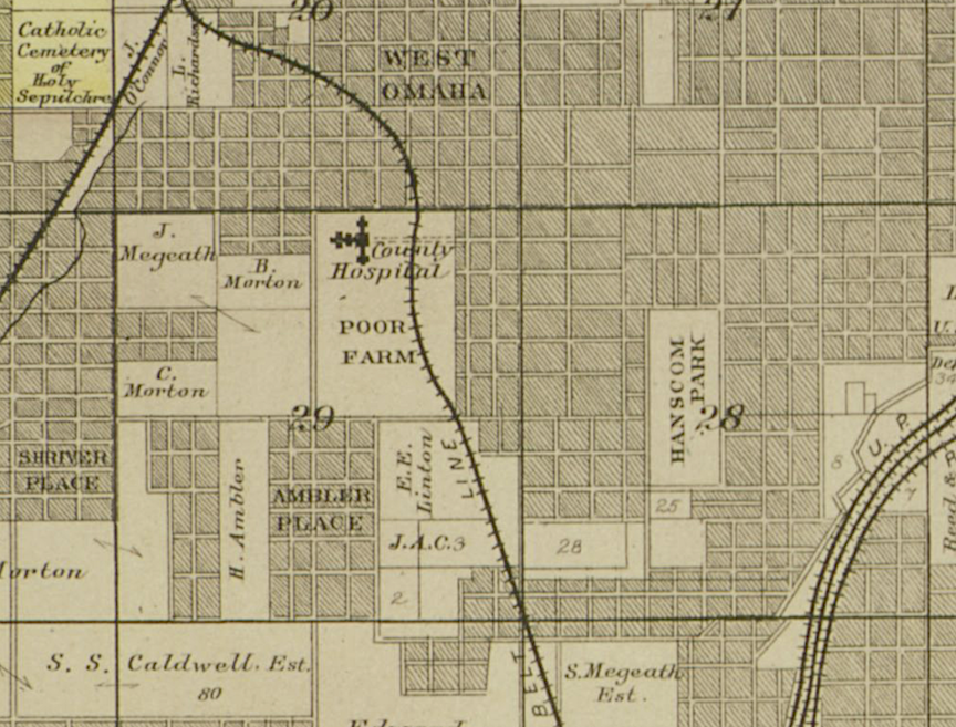
The Douglas County Commissioners acquired the land in 1859 for the establishment of the County Poor Farm, which initially encompassed 160 acres. There is considerable disagreement and mystery regarding the Douglas County Poor Farm and the later establishment of the Douglas County Hospital. I have endeavored to research and refine these contradictions as thoroughly as possible throughout the years.
The County Poor Farm comprised 160 acres of rural land where the poor of the city were made to/given a place to live and work. Numerous texts address the dire squalor of these conditions. It is assumed from other writing that the inhabitants of the farm were unable to attain employment either for physical health reasons, mental health, behavioral or cognitive impairments. I am still unclear on who was picked or “sent” to the Poor Farm. County Poor Farms existed throughout the country. A county poor farm was a government-subsidized institution that functioned as a farm, offering shelter, sustenance, clothing, and medical assistance to individuals in need. Poor farms were sometimes referred to as poorhouses, almshouses, or workhouses. Poor farms were operated nationally by counties or local municipalities and aimed to assist and employ individuals who could not sustain themselves. When the Douglas County Poor Farm was initiated, it was far outside of the Omaha proper limits and considered a rural environment that wouldn’t be obtrusive to polite society.
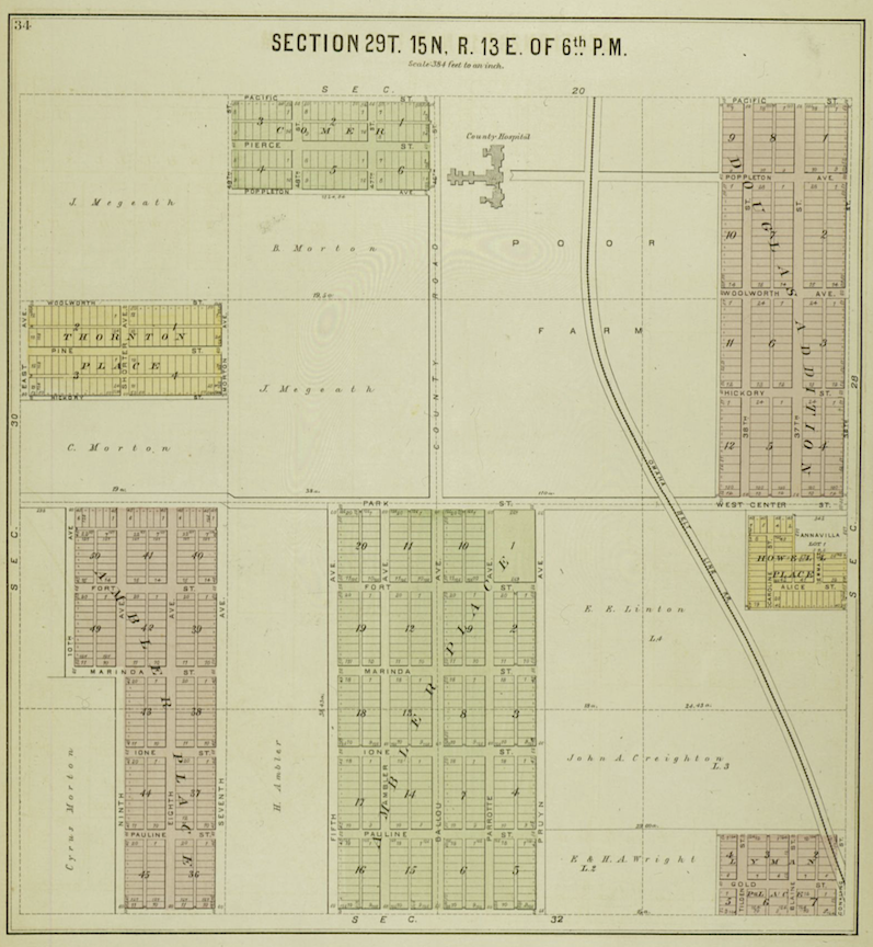
Plat Map of Douglas and Sarpy Counties, Nebraska. Compiled by C. H. Scoville. Published by Midland Guarantee & Trust Co. Digital Publisher: Omaha Public Library. Date: 1889.
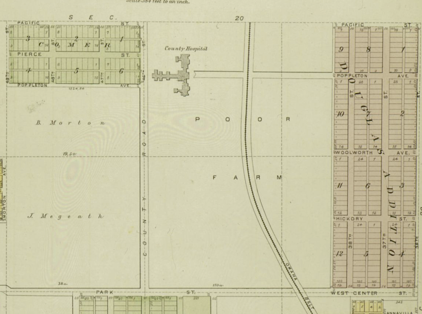
Detail of the above 1889 map. This map shows that the County Poor Farm extended all the way to Center Street on the south, County Road (labeled as 46th Street) on the west, Pacific Street on the north and an unlabeled street on the east. The Omaha Belt Line clearly ran through the center of the farm. The following article reveals this unlabeled, eastern street at 36th Street.
According to The Daily Bee of September 1888, the Douglas County Poor Farm was situated to face 36th Street, just south of Poppleton Avenue. The Hascall House building was an L-shaped, two-story, brick with a basement. There was where Omaha’s “paupers” lived, 13 cots crowded to a room. A nursery and other wards existed. The basement of the primary structure served as a dining area for the residents. To the south, there was a coal house, and adjacent to the main structure was a 12 by 12-foot “dead house” where the deceased were placed. I have also written of the suspicioned Poor Farm Cemetery, believed to be located on the eastern edge of the property. The Douglas County Death Register has lists of individuals interred at the Poor Farm Cemetery. I obsess about this. A separate outbuilding was utilized by two farm hands. Eighty inmates, as they were called, lived there and worked the farm.
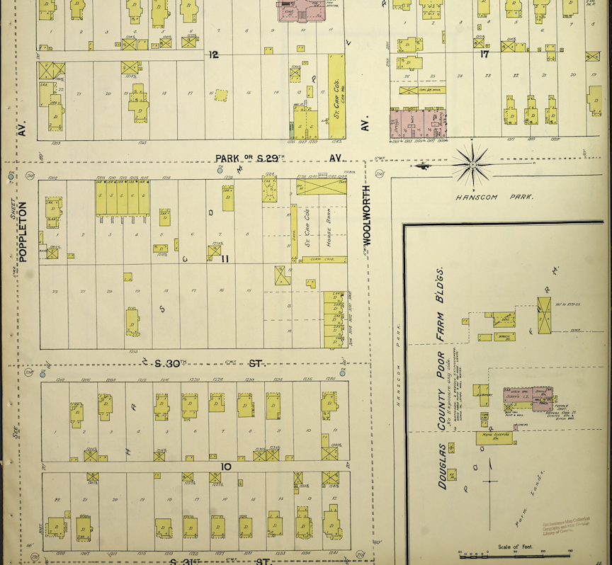
Sanborn Fire Insurance Map from Omaha, Douglas and Sarpy County, Nebraska, Vol. 1, 1890, Plate 0046. Do not get caught up in the numeric street names, as they changed over time. If you have hung around here long enough, you surely recognize the ever changing street names over time. I appreciate the Sanborn maps for their structural detailing and land footprint representation. As one can assess, the city grew in around the Poor Farm.
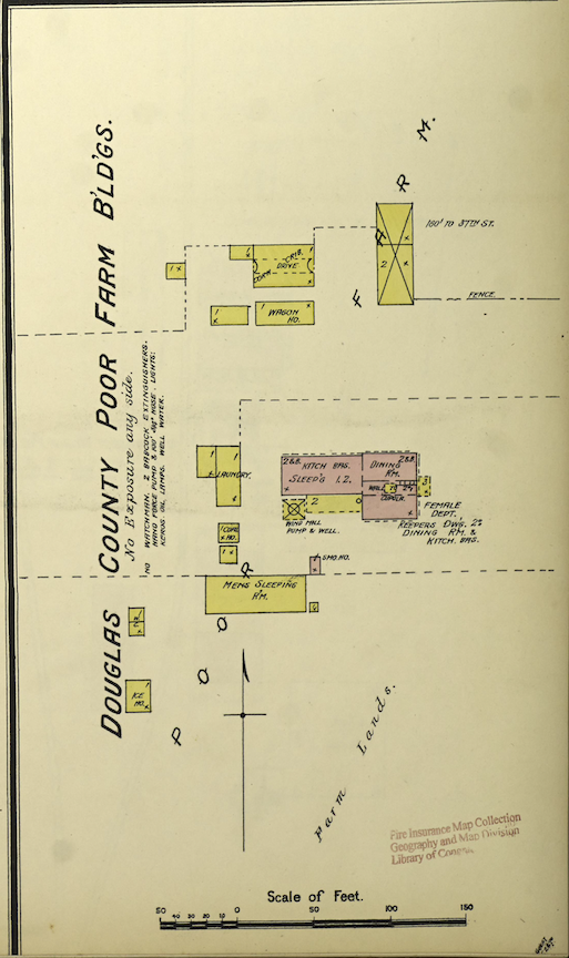
Magnified. Sanborn Fire Insurance Map from Omaha, Douglas and Sarpy County, Nebraska, Vol. 1, 1890, Plate 0046. Get out your magnifying glass. Interesting.
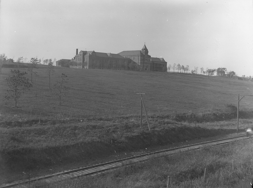
The “old” Douglas County Hospital faced east on large country property. Camera looks northwest from 38th and Center Streets. Railroad tracks in the foreground are the Missouri Pacific Belt Line, also called the Omaha Belt Line. Bostwick, Louis (1868-1943) and Frohardt, Homer (1885-1972).
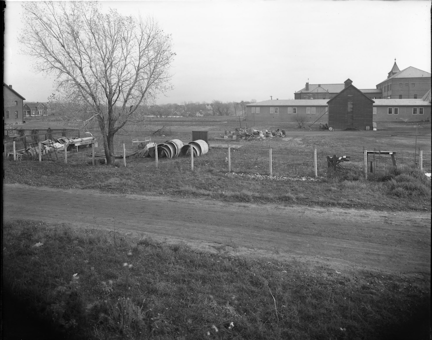
The Douglas County Poor Farm near 42nd and Woolworth Ave. Camera faces east. Note the hospital in the distance and the many outbuildings. Bostwick, Louis (1868-1943) and Frohardt, Homer (1885-1972). 1918
A large building, which later was referred to as the “old Douglas County Hospital” was designed by the architectural firm E. E. Meyers & Sons. Despite common assertions that construction was finalized in 1886, the newspapers at the time stated that the hospital was not completed until December of 1890. There were 90 “unfortunates” of the Poor Farm who “had regrets to leave the old house” (The Hascall House) to move into the newly built hospital. Political figures were red hot mad, arguing “the county has no authority to open the hospital as such an institution.” The Daily Bee was forthright in their opinion “that the Douglas County Hospital should not be used as an asylum for the incurable insane.”
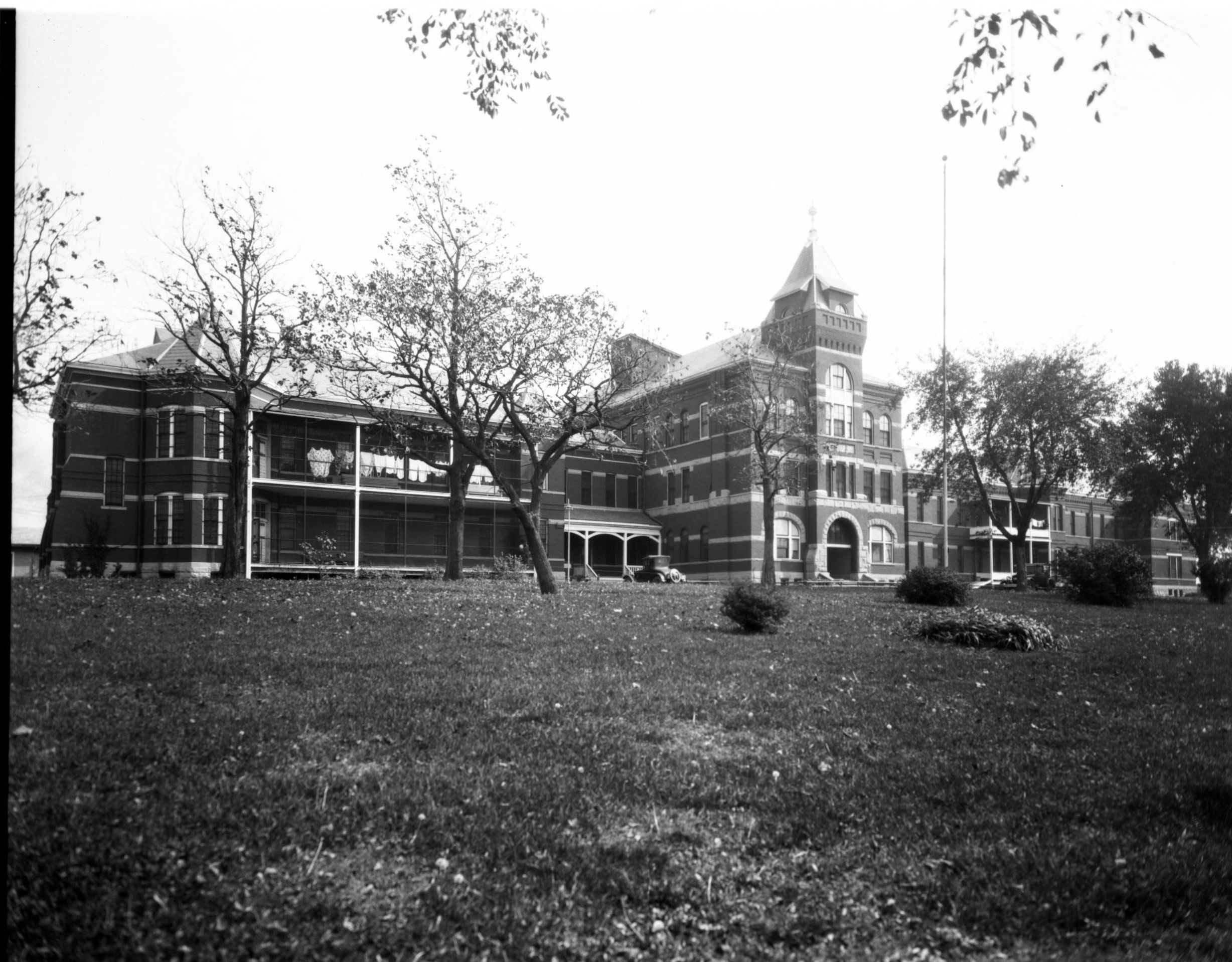
A view of the old county hospital and the grounds around it. Bostwick, Louis (1868-1943) and Frohardt, Homer (1885-1972). The Durham Museum. 1926.
The old hospital was comprised of two sections, said to be of Victorian influence, constructed of red brick with principal facades facing east. Due to poor workmanship and inferior building materials, a wing cracked off and another collapses, damaging the walls and roof shortly after it was completed. Other additions were made over time and I believe the previous photo depicted those later renovations. Scandalous as it was at the time, although called a hospital, this building served as housing, workspace, and infirmary for Omaha’s poor as well as offices for the county workers.
Conditions at the “old” Douglas County Hospital were as deplorable as that of The Hascall House. The dimensions of a patient’s room on the first floor of the “old” County Hospital were approximately 6.5 by 10 feet. Allegedly, the “catacombs” were situated in the basement. These were described as small, open cubicles resembling monks’ cells, positioned on either side of corridors measuring five feet from floor to ceiling. The city’s impoverished, homeless men, along with a few terminally sick individuals, resided here. Any detainee above five feet in height was compelled to stoop in the dungeons. In spite of this, it is said that these elderly men living in the dirt-floored basement of the tombs refused to leave. When the County Commissioner of 1914 suggested moving them upstairs into better accommodations, the men “complained shrilly and refused to leave.” The Medical Association viewed the “old” County Hospital as “a relic of the Middle Ages.” Personally I do not shy away from darkness but even I was deeply repulsed by some of the things I read about hygiene of the patients and vermin.
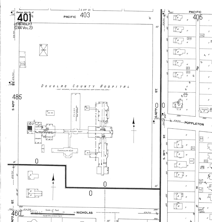
Sanborn Insurance Map from 1918. Great map lent by Shelley McCafferty of Omaha City Planning. Note the upper left hand corner by 42nd and Pacific. Also notice the map has gotten smaller. Oddly the County’s land ends at 40th Street but the developed property where houses are depicted abuts at 36th Street.
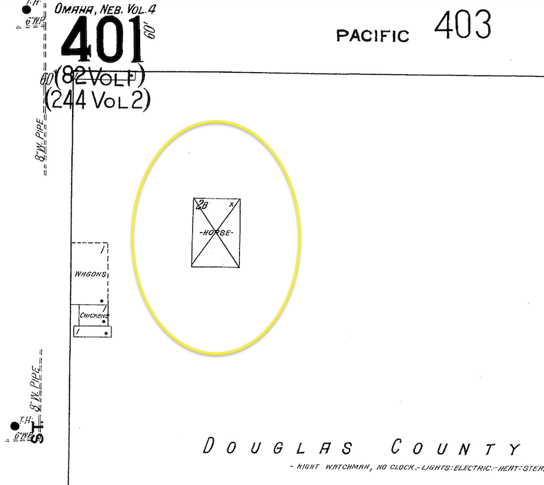
Sanborn Insurance Map from 1918. Map lent by Shelley McCafferty of Omaha City Planning. Magnified. There it is folks, right on the corner of 42nd and Pacific. The wagons, chickens and horse stables were kept where our 1101 South 42nd Street would later be built.
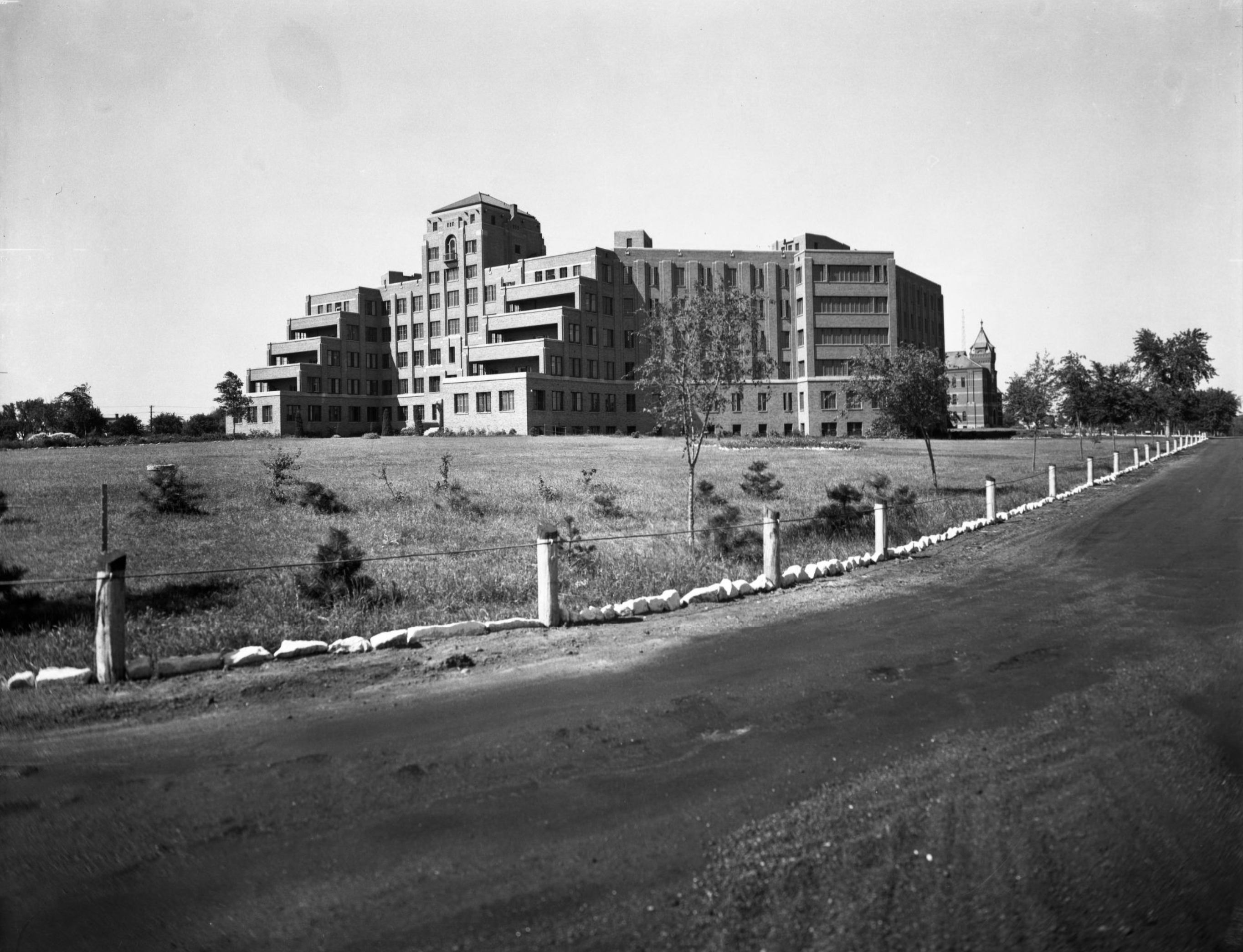
The “New” Douglas County Hospital. Bostwick, Louis and Frohardt, Homer. The Durham Museaum. 1937-09-19. Inside a sign reads, “Original site of the first Douglas County Tuberculosis Hospital, Poor Farm, and Pest House.”
South of the old hospital, the “new” Douglas County Hospital, (4102 Woolworth Avenue) was designed by John Latenser & Sons, erected in 1932. The New hospital had a southern facing elevations and its standout feature was the staggered, step-up plan, as embodied in the terraced sun porches of the past. The entire cost of the hospital was $895,338 and was steeped in scrutiny from the start, as the funds were raised from a bond issue and the transfer of a certain amount from the county home appropriation. This remarkable photo makes plain the once open terraced sun porches, so interesting for an institution. Please note the long drive running up the eastern side of the property. The “old” hospital is seen in the background to the north.
At the time of the WPA’s 1935-1939 Omaha: A Guide to the City and Environs, only forty acres of the original Poor Farm’s 160 acres remained as the Douglas County Hospital grounds, while 120 acres were leased to the Omaha Field Club for their golf course. In early 1926, a public health initiative spearheaded by the Omaha-Douglas County Medical Society aimed to establish a Poor Farm distinct from the Douglas County Hospital. Because of this, the “aged poor” were relocated from the Douglas County Hospital premises to the Clearview County Home in 1931, while the “indigent sick” remained at the 42nd and Woolworth location. Of interest, Douglas County has an arrangement with and continues to lease the county land to the Field Club for their golf course and grounds. The northeastern most part of the golf course is owned by Metropolitan Utilities District. I have covered this bit of underground intrigue in a past article. The Invisible House Next Door. Douglas County sold their large swath of land directly south to the United States Federal Government for use of the Veterans Administration Hospital.
Hospital Grounds Become County Grounds
Throughout the existence of the Poor Farm and Douglas County Hospital, both old and new, several outbuildings and structures were present on the property for county utilization. There were also brick yards located on the grounds. It was all quite interesting to me the more I dug in. Due to the subdued nature of these government buildings, their construction often lacked significant commotion in the press.
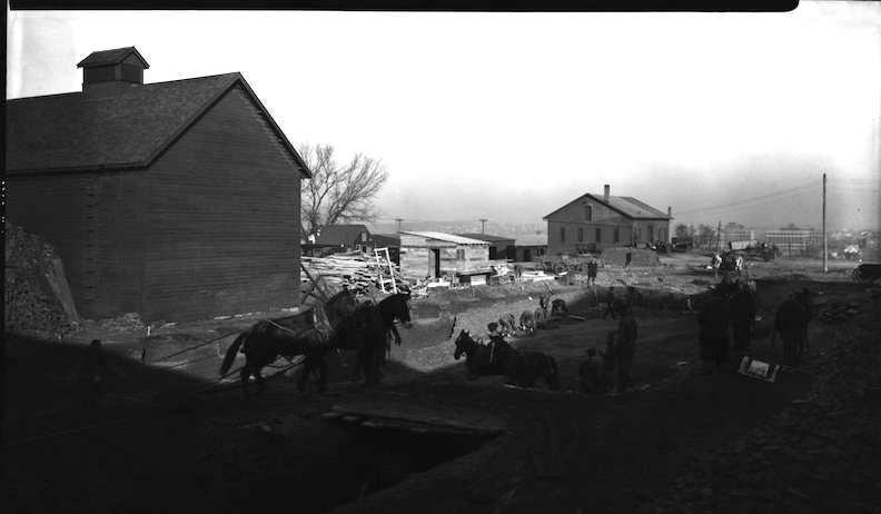
Workers excavating area around County Hospital on 42nd Street and Woolworth Avenue. Bostwick, Louis (1868-1943) and Frohardt, Homer (1885-1972.) The Durham Museum. 1923.
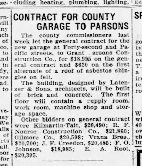
However, the building in question, tonight’s obsession at 1101 South 42nd Street did attract some attention in Omaha. A County Garage was to be constructed near the site of the previously shown horse stable and wagon building.
July of 1924. Omaha World-Herald.
Latenser & Sons Design
In July of 1924, the Omaha World Herald announced the county commissioners were having a County Garage built the northwestern corner of the County parcel. I discovered a Douglas County Garage was functioning by at least 1920 and this was where the road machinery was kept. Additionally if cars were left abandoned or “in question” throughout the city, they were towed there. County vehicle repairs also happened in this garage.
The County Garage building was designed by Lateness & Sons, architects, built of brick and concrete. The first floor was said to contain a supply room, work room, machine shop and storage space. By 1925 the county had their new building. According to the Place Makers of Nebraska: The Architects on the History Nebraska website, John Latenser & Sons, architects, operated from 1915 to 1978. John Latenser & Sons was a prominent firm in Omaha established by John Latenser, who had been practicing in the city since 1885. In 1915, he incorporated his two architect sons, John Jr. and Frank, as partners in the company. John Latenser & Sons are frequently referenced in My Omaha Obsession because of their exceptional architectural designs, innovation and timeless buildings, which were constructed for durability. As mentioned earlier, the group had already designed the “new” Douglas County Hospital on the County Poor Farm property. On that note, this firm appeared to have an arrangement with the local government or their bids were consistently selected. Many of their stately buildings are still standing to include schools, churches, government buildings; many are included on the National Register of Historic Places.
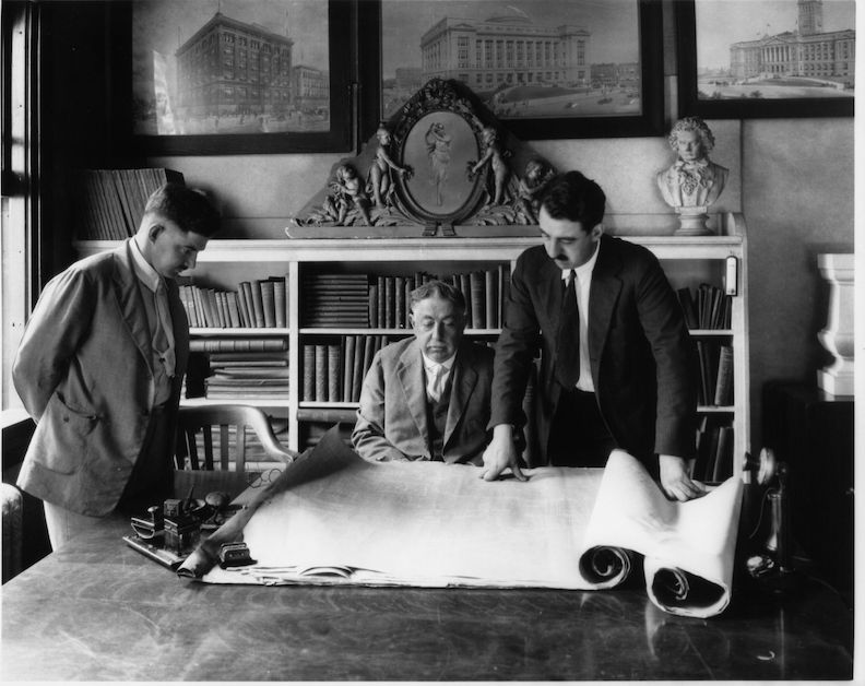
John Latenser and his sons at the office. Bostwick, Louis (1868-1943) and Frohardt, Homer (1885-1972). 1921.
The Douglas County Garage at 1101 South 42nd Street, although a modest, functional building in its day was included on the Latenser & Sons list of commissions with the state.
Other Latenser Solid Gold Hits:

Scottish Rite Cathedral, 202 South 20th Street, built in 1912. Photo by my Omaha hero, Lynn Meyer.
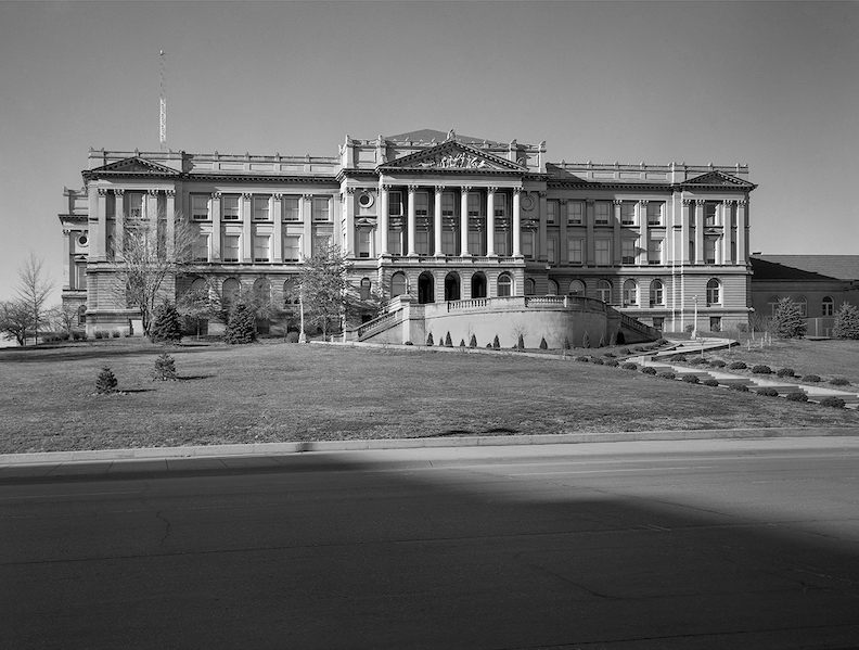
Central High School, 124 North 20th Street, built in 1900-1912. Photograph by D. Murphy.

Douglas County Courthouse. 1701 Farnam Street. Built in 1909-1913. Photograph by Nathan L. Dewell Collection, Nebraska State Historical Society.
Back to the County
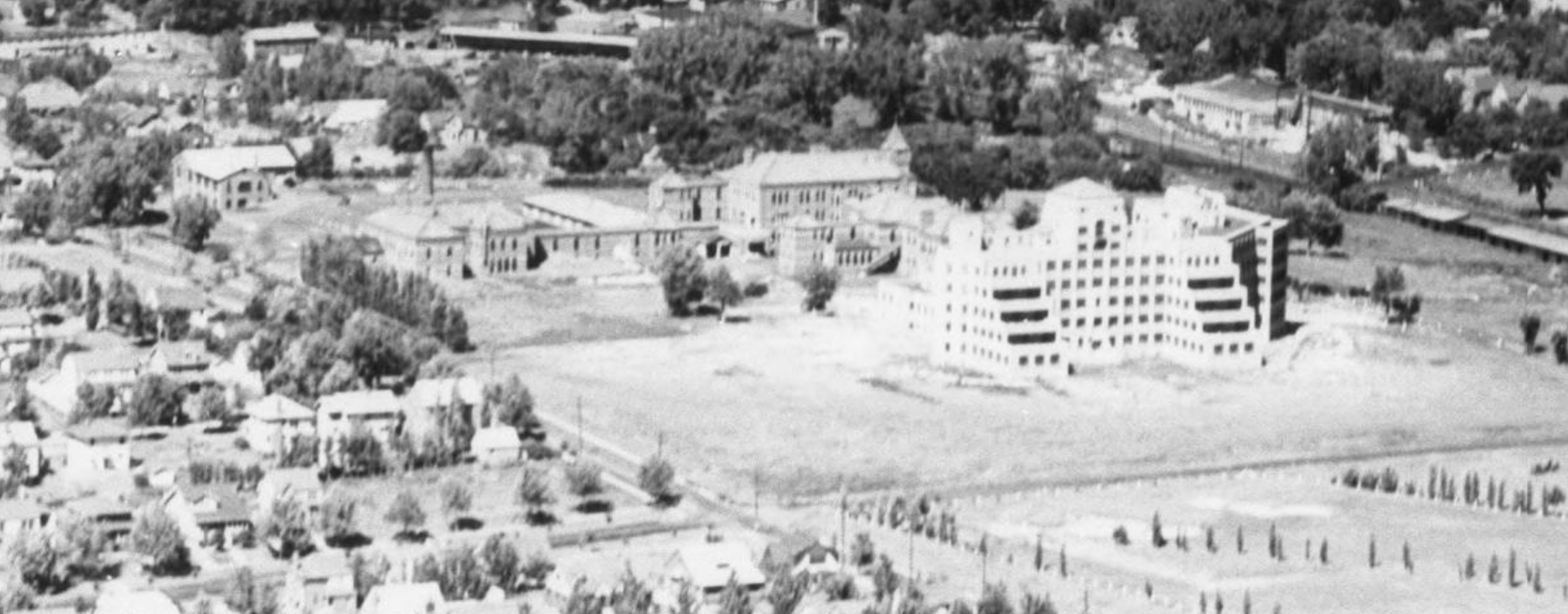
This great aerial photo lends so much. One can see how the large Poor Farm had transitioned to a collection of county buildings. Camera is looking north/northeast over the Douglas County Hospital at 42nd and Woolworth. Bostwick, Louis and Frohardt, Homer. 1933.
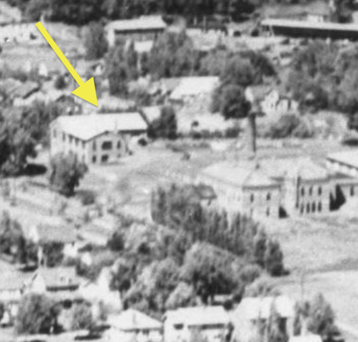
There it is. 1101 South 42nd Street.
By January of 1947, the “old” Douglas County Hospital had been demolished. I love these following photographs that show the stark grounds. The eastern part of the large parcel remains a farm. The smokestack, still present in 2024, is seen on the far right side of this image. A white arrow points to the County Garage.
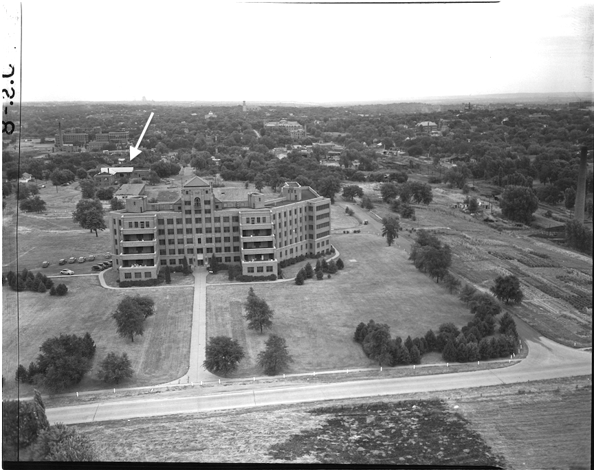
An aerial photograph of the Douglas County Hospital grounds. Photograph by John Savage. The Durham Museum. 1947.
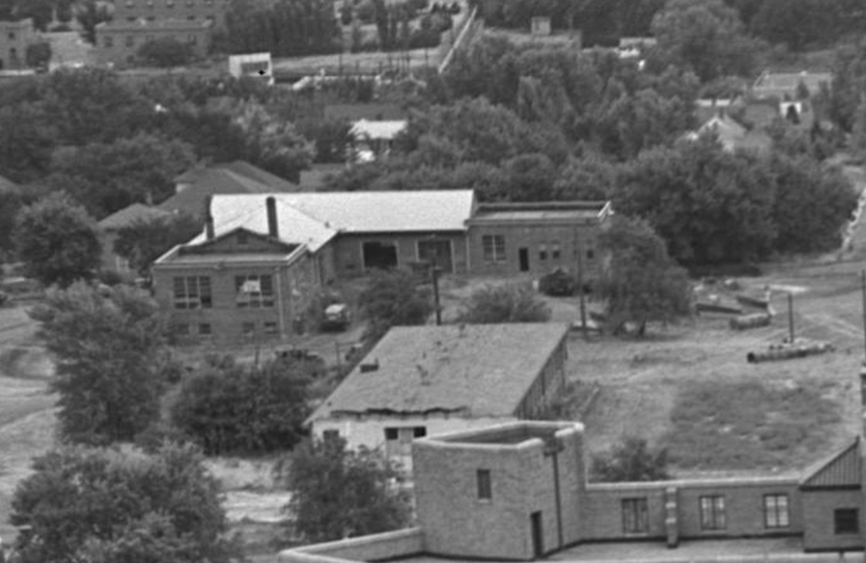
Detail of the County Garage.
The Assistance Bureau Building
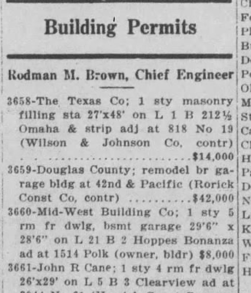
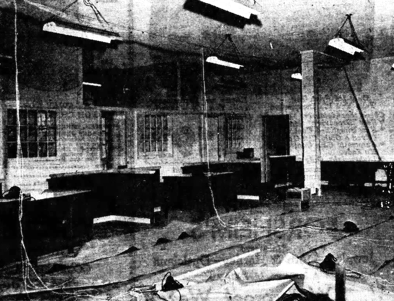
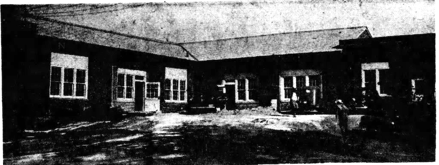
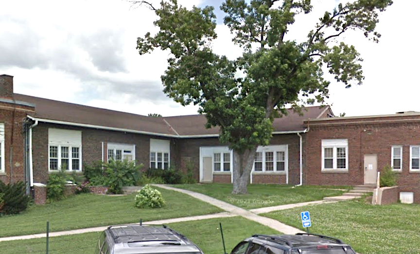
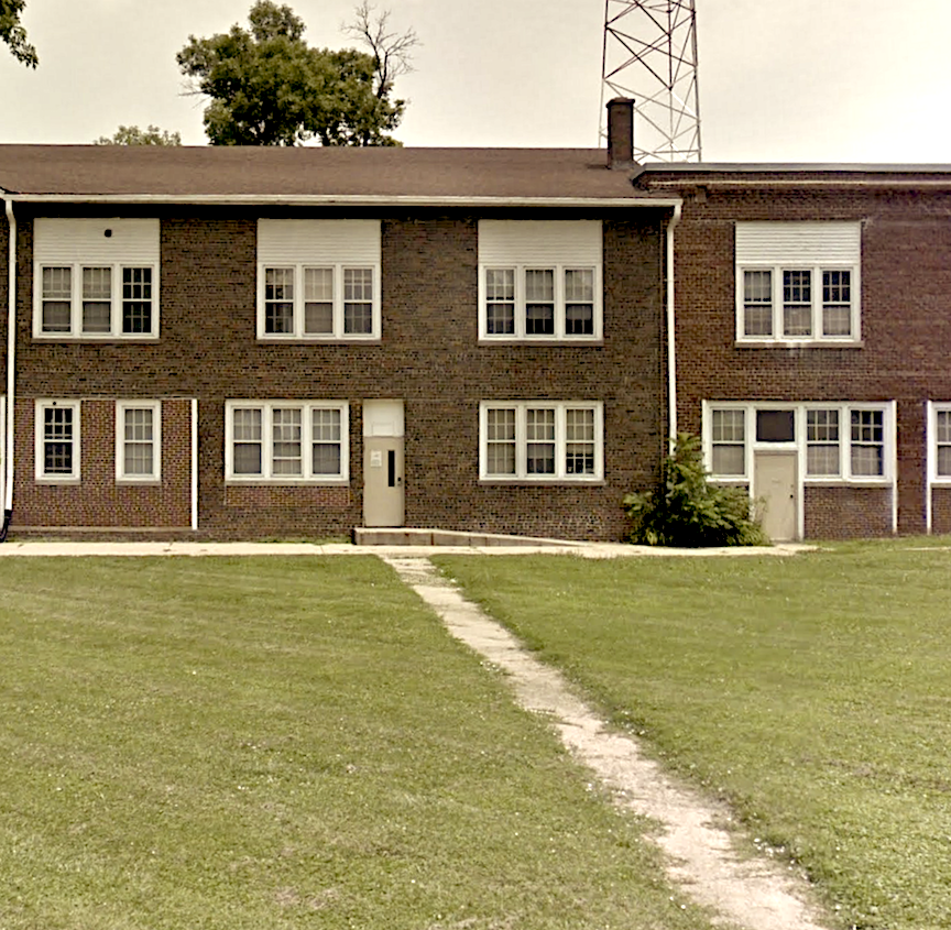
By 1949 the Douglas County Assistance Bureau had tired of their location at 2101 Cuming. There were plans to convert “the old County Garage at Forty-second and Pacific Streets” into their Social Services office. With plans drawn up by Architect Frank Latenser (one of John Latenser’s sons and partner), the County Garages would be renovated. The Clearview Home grounds, where the “old and indigent” population had been moved to, would host a new County Garage.
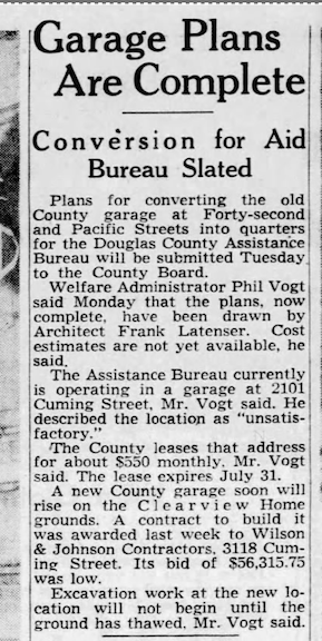
March 15, 1949. Omaha World-Herald.
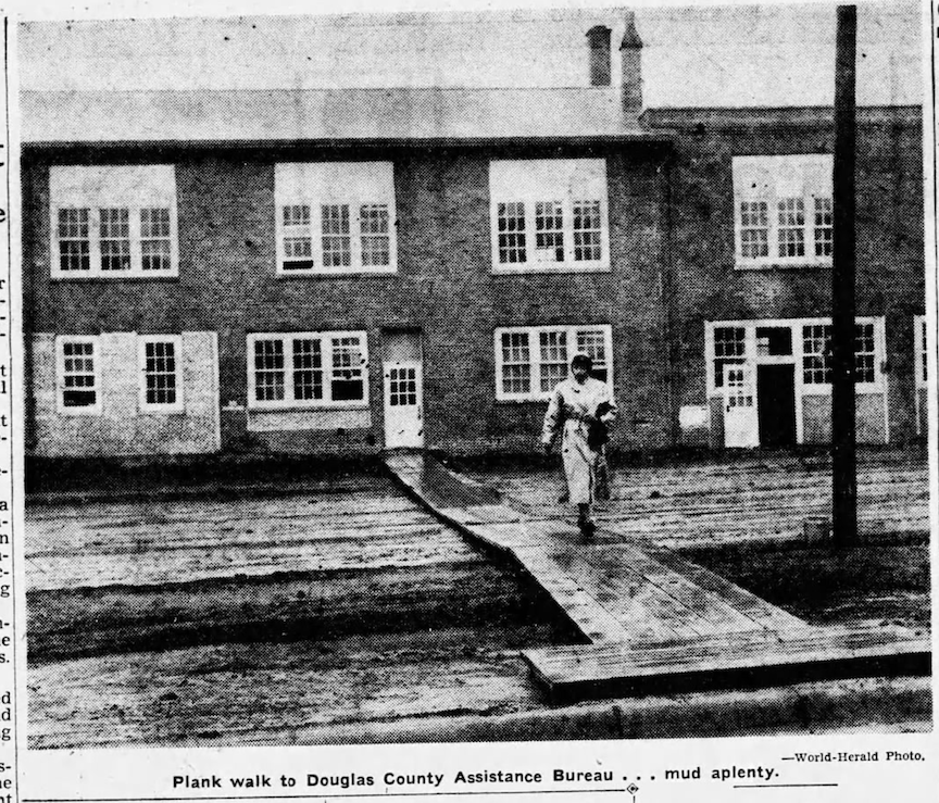
1960s Growth of Human Services
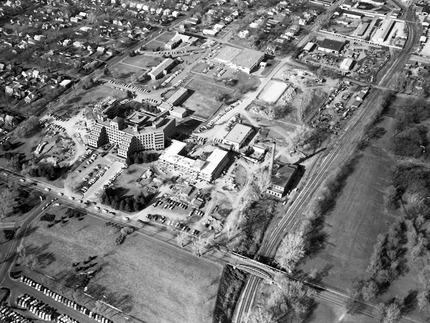
An aerial view of the Douglas County Hospital at 42nd and Woolworth Streets, looking north. Paskach, Robert. Durham. 1964. Much expansion. I like to study the train tracks and the old bridge over the tracks, between the County property and the Field Club. These tracks are now a wonderful walking path.
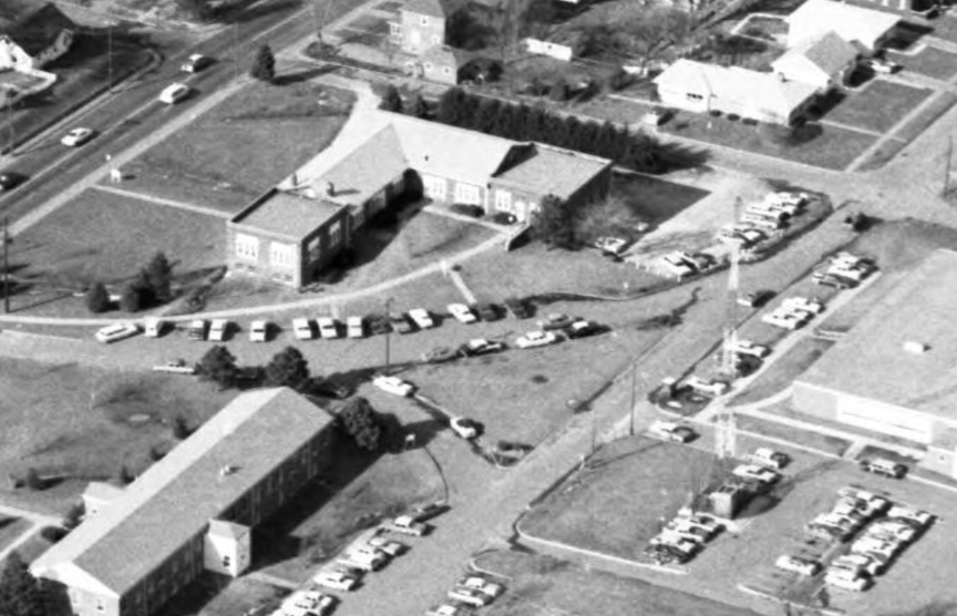
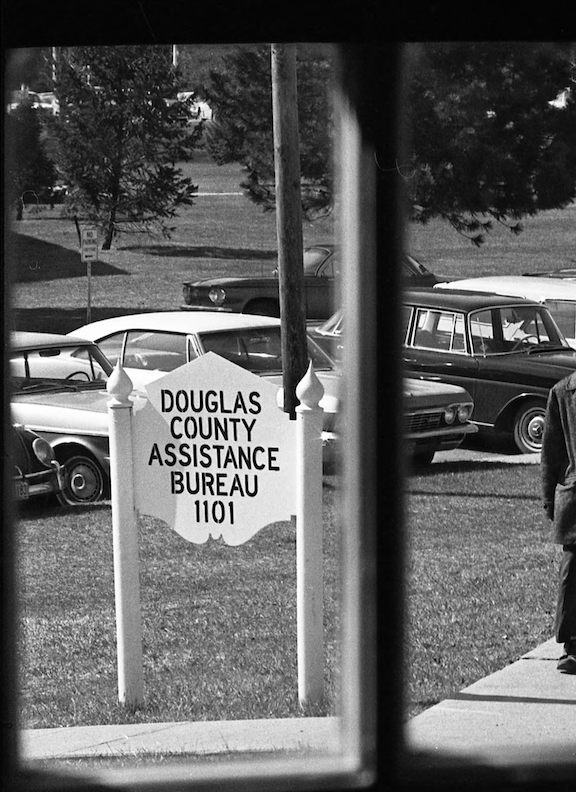
Douglas County Assistance Bureau, 1101 South 42nd Street. Remember these signs?? It’s all coming back now. I had forgotten all about these type of signs around town. Robert Paskach, 1968
In its time the Douglas County Assistance Bureau and its tireless workers have been known by many names. In the 1980s they were simply called Douglas County Social Services. In the 1960 and 70s they were called the Douglas County Welfare Office. Later still the Nebraska Department of Health and Human Services. This office served as the government agency responsible for the coordination, funding and oversight of community-based services related to behavioral health, developmental disabilities, public health, elder care services, economic and medical assistance programs, adult protective services. They were still working from this once County Garage in 2013, maybe later.
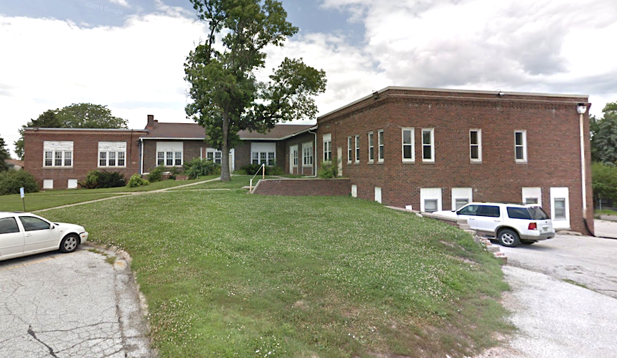
Eastern most wing. What one would have seen if one was sneak parking like I was to get closest to the thrift store doors.
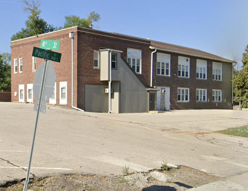
Northern elevation.
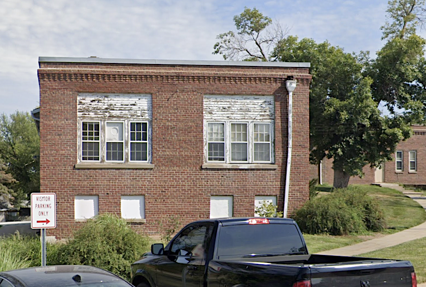
The southern and eastern wings offer a flat roof with some proper elaborations that I enjoyed. The middle portion has a gable roof.
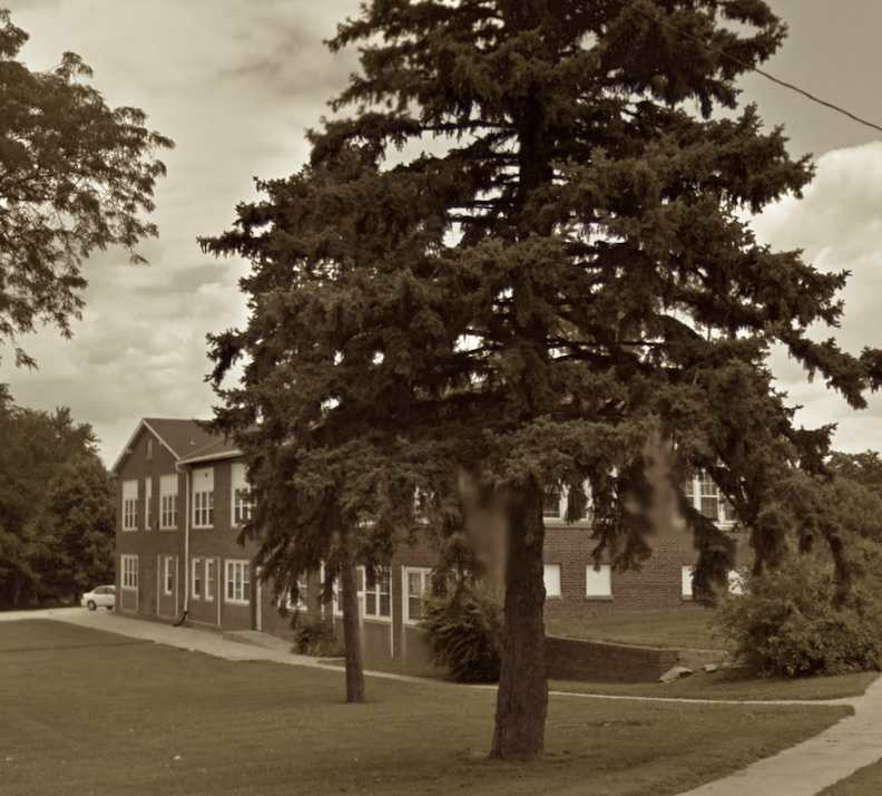
Camera faces northeast.
Demo Time
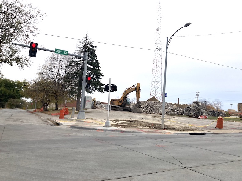


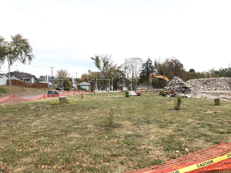
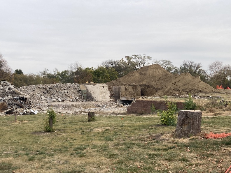
The Plan?
So what is the overall plan for this section of the County’s property? Yes, wise ones, we would imagine it will be another County Building. I contacted my associate at the County Deed’s office, and he was unaware. I similarly observe no information on the Omaha Planning site. I am curious whether, due to its status as County, there is no requirement for them to obtain consent from the County or City for construction. I may be unclear on that matter and would welcome any clarification.
**Addendum of November 12, 2024** Tim Heller wrote in with just the information we needed. Mr. Heller is chair of the State Advisory Board for Behavioral Health and serves on the Olmstead Commission (housing for those with disabilities). He reported: “The new mental health center is the result of Douglas County ARPA monies. Certain Douglas County Board members were pushing for a combined center adjacent to the DC Jail. Myself, Ernie Chambers, and Hal Daub opposed that. (…) So, the jail got money to build a new mental health wing. Ground is already broken for that. It was needed. I pushed for a public private partnership that would allow more beds, than the 19 under the IMD exclusion. Interestingly, that piece of legislation was the last bill JFK signed before flying to Dallas. It was designed to all but eliminate mental institutions. The final closures occurred under Reagan. A work around can be obtained by partnering with a hospital with more beds. DC didn’t really pursue this as an option. Sad. So they are building a 19 bed facility (…) We need many more beds in a city this size.” Thank you, Tim!
Thanks and good cheer to Bobby Wilkerson, Bruce Karlquist and David Johnson for the inspiration, curiosity and friendship.
I welcome your feedback and comments on these great Omaha properties. They worked so hard! Let’s hear it for 3572 Leavenworth and for 1101 South 42nd Street. Please share your additional clues to the story in the “Comments,” as we know more together. Everyone would love to read what you have to say and it makes the sharing of Omaha history more fun. You can use an anonymous smokescreen name if need be. We want to hear from you.
You can keep up with my latest investigations by joining my email group. Click on “Contact” then look for “Sign me up for the Newsletter!” Enter your email address. You will get sent email updates every time I have written a new article. Also feel free to join My Omaha Obsession on Facebook. Thank you, Omaha friends. Miss Cassette
© Miss Cassette and myomahaobsession, 2024 Unauthorized use and/or duplication of this material without express and written permission from this site’s author and/or owner is strictly prohibited. Excerpts and links may be used, provided that full and clear credit is given to Miss Cassette and myomahaobsession with appropriate and specific direction to the original content.

If you are looking for more architectural and Omaha history sleuthing fun, ask your local or bigbox bookseller for my book: My Omaha Obsession: Searching for the City. Also available everywhere online. Thank you.
The Family Dollar was a grocery store in the 80’s. Spartan Foods? I use to buy cases of Blatz beer there; returnable bottles.
Hi Dave, Are you saying Spartan was in the location after Perelman’s Super Market?
This location at 42nd & Pacific will be the new Douglas County Mental Health Clinic and hospital. Sadly, it will only have 19 beds, when more are needed. This is due to the IMD exclusion. Interestingly, that law was the last law signed by JFK before his fateful trip to Dallas. If you would like more information on this, you can contact me.
That law is why Richard Young Hospital (515 S 26th St) closed.
Our only long term care mental hospitals are now the Lincoln & Hastings Regional Centers. The Norfolk Regional Center is strictly for sex offenders.
Thank you, Tim! I really really appreciate this. I will email you tomorrow.
I believe it was a Spartan store. I moved to that area in 1980 and would pick up last minute items there. The houses in that vicinity (many now gone) still retained the distinction of every house being different from each other in style – definitely not cookie cutter.
As an aside, and an addendum, there were 4 houses on 37th street between Leavenworth and Jones (now demolished). i remember Greg Jahn of Landmarks telling me that he thought one of them was an original Pony Express station. Made sense considering the “watering hole” across Leavenworth street and the fact that A.D. Jones was the original postmaster of Omaha. I don’t think it ever got researched.
Wow! Synchronicity! I covered the watering hole in “the mansion in the trees” story. And I am writing about A. D. Jones right now front upcoming mystery! Thanks so much, John. You always add so much.
Case 2, The old hospital is pure victorian gothic horror – an American horror story,
“adjacent to the main structure was a 12 by 12-foot “dead house” where the deceased were placed. I have also written of the suspicioned Poor Farm Cemetery, believed to be located on the eastern edge of the property”.
Was there really a Poor Farm Cemetery on that site? Were the graves moved at some point?
Case 1 is more disturbing though. I think our university’s planning, architecture, and maybe most importantly design programs have failed society.
All if these new 5 story, TIF funded, relatively inexpensive to build boxes of dormitories deliver developers enormous wealth, and they have little responsibility if they fail. 5/1 buildings have short lifespans before needing major maintenance – 30 years by most accounts. There’s no argument against development. But should lift people up, not box them ip into a carton.
Good development isn’t car-centric. Good development creates welcoming, walkable places and buildings that engage with the established character of neighborhoods. What is being built around us today is the complete antithesis.
Society is oblivious to the master plan: put everyone into cash cow rental properties, eliminate the American dream of home ownership for the majority.